Southbourne Beach

Uploader's Comments
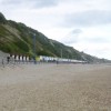
Shingle near the sea, sand higher up. Left, in the distance, beach huts; in the far distance, the outlines of Hengistbury Head and Isle of Wight.
Uploaded to Geograph by Mike Faherty on 21 August 2014
Shingle near the sea, sand higher up. Left, in the distance, beach huts; in the far distance, the outlines of Hengistbury Head and Isle of Wight.
Uploaded to Geograph by Mike Faherty on 21 August 2014
 Photo © Mike Faherty, 21 August 2014.
Licensed for reuse under this Creative Commons licence
Photo © Mike Faherty, 21 August 2014.
Licensed for reuse under this Creative Commons licence
Location: West Southbourne, Bournemouth
Location type: Urban
OS Grid: SZ129912
Coordinates: 50°43'14"N 1°49'3"W
Mapcode: GBR XH7.N2
What 3 Words: groups.repair.push
Coordinates and location codes are for an approximate mid-point of the beach, and may not reflect the best access point or the most popular part of the beach.
Country: England
Local Authority: Bournemouth
Nearest postcode: BH6 3TD
(for sat-nav purposes only, a beach does not have a postal address!)