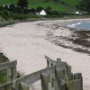
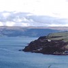
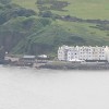
View across the strand at Cushendun towards Scotland

Uploader's Comments
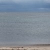
The landmass on the left and beyond the rain shower is the Mull of Kintyre. The island of Sanda is on the right
Uploaded to Geograph by Eric Jones on 13 August 2011
The landmass on the left and beyond the rain shower is the Mull of Kintyre. The island of Sanda is on the right
Uploaded to Geograph by Eric Jones on 13 August 2011
 Photo © Eric Jones, 13 August 2011.
Licensed for reuse under this Creative Commons licence
Photo © Eric Jones, 13 August 2011.
Licensed for reuse under this Creative Commons licence
Location: Cushendun
Coordinates: 55°7'38"N 6°2'31"W
Mapcode: IRL VD.GL63
What 3 Words: laying.bubble.dragonfly
Coordinates and location codes are for an approximate mid-point of the beach, and may not reflect the best access point or the most popular part of the beach.
County: Antrim
Country: Northern Ireland
Local Authority: Moyle
Nearest postcode: BT44 0PJ
(for sat-nav purposes only, a beach does not have a postal address!)