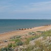
Sea Defences, Hythe

Uploader's Comments
Large embankment with road and path along the top.
Uploaded to Geograph by Oast House Archive on 11 July 2010
Large embankment with road and path along the top.
Uploaded to Geograph by Oast House Archive on 11 July 2010
 Photo © Oast House Archive, 11 July 2010.
Licensed for reuse under this Creative Commons licence
Photo © Oast House Archive, 11 July 2010.
Licensed for reuse under this Creative Commons licence
Location: Botolph's Bridge
Location type: Village
Nearest village: Burmarsh
OS Grid: TR126317
Coordinates: 51°2'45"N 1°1'57"E
Mapcode: GBR V0X.9XB
What 3 Words: brightly.shrug.wand
Coordinates and location codes are for an approximate mid-point of the beach, and may not reflect the best access point or the most popular part of the beach.
County: Kent
Country: England
Local Authority: Shepway
Parish: Dymchurch
Nearest postcode: TN29 0TX
(for sat-nav purposes only, a beach does not have a postal address!)