Bovisand : Staddon Point & Coastline

Uploader's Comments
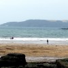
Looking across the coastline to Staddon Point.
Uploaded to Geograph by Lewis Clarke on 25 July 2012
Looking across the coastline to Staddon Point.
Uploaded to Geograph by Lewis Clarke on 25 July 2012
 Photo © Lewis Clarke, 25 July 2012.
Licensed for reuse under this Creative Commons licence
Photo © Lewis Clarke, 25 July 2012.
Licensed for reuse under this Creative Commons licence
Location: Down Thomas
Location type: Village
OS Grid: SX492505
Coordinates: 50°20'8"N 4°7'11"W
Mapcode: GBR NX.X9LV
What 3 Words: vote.fans.healers
Coordinates and location codes are for an approximate mid-point of the beach, and may not reflect the best access point or the most popular part of the beach.
County: Devon
Country: England
Local Authority: South Hams
Parish: Wembury
Nearest postcode: PL9 0AD
(for sat-nav purposes only, a beach does not have a postal address!)