Approximate Location Map
Use two fingers to pan or zoom the map
Use two fingers to pan or zoom the map
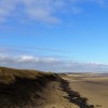
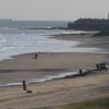
The beach is characterised by its long stretch of sand, interspersed with a very long pier and various working pipelines. In the 1930s, industrial works alongside this part of the coastline extracted magnesia (magnesium carbonate) from dolomitic lime and seawater, although today, all that remains of this industrial site are some derelict buildings, old pipes, and the remains of Steetley Pier.
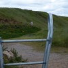
The beach can be accessed by parking at West View Road and walking through the tunnel which passes under the railway line. Then, walk towards the sea, past the former industrial buildings, and turn right, towards the old pier.
The beach is often deserted and has no restrictions on dog walking. To get the most from this beach, it is recommended to check tidal tables and time your visit to coincide with low tide, when a vast amount of golden sand, interspersed with pipes, is exposed. The beach is backed by a cemetery and further north, by Hartlepool Golf Course, beyond which lies the Durham Coast Nature Reserve. Hartlepool Marina lies to the south of the beach.
There is a fish and chip shop nearby, and more places to eat and shops can be found in Hartlepool.
Sand
| Today | |
|---|---|
| Chance of rain | 86% |
| Max temperature | 16°C |
| feels like | 16°C |
| Wind 20mph | |
| Max UV Index |
| Tonight | |
|---|---|
| Chance of rain | 30% |
| Min temperature | 11°C |
| feels like | 11°C |
| Wind 16mph |
The tide at Hartlepool North Sands is currently falling. Low tide will be at approximately 12:55 PM, and the next high tide will be at approximately 7:10 PM.
![]() Today's air pollution levels are forecast to be Low
Today's air pollution levels are forecast to be Low
There is a large car park in the marina.
Dogs are allowed
No lifeguard cover at this beach
Water quality not measured here
5 College Square

From £1707.00 per week at Sykes Holiday Cottages
Magnolia Cottage

From £1600.00 per week at Sykes Holiday Cottages
St Hilda's Cottage

From £2176.00 per week at Sykes Holiday Cottages
Postmanâs Lodge

From £1291.00 per week at Sykes Holiday Cottages
Cosy Cottage 3

From £1140.00 per week at Sykes Holiday Cottages
Holly Cottage

From £1776.00 per week at Sykes Holiday Cottages
Museum of Hartlepool (1.2 miles)
Hartlepool Quay (1.2 miles)
National Museum of the Royal Navy Hartlepool (1.3 miles)
Heugh Battery Museum (1.3 miles)
HMS Trincomalee (2.3 miles)
Summerhill Country Park and Outdoor Activities Centre (2.5 miles)
Tweddle Children's Animal Farm (2.9 miles)
Ward Jackson Park (6.2 miles)
All distances are approximate
just over a mile northwest as the seagull flies, around 3 miles by road or just over a mile on foot using coastal paths.
around 2 miles northwest as the seagull flies, around 4 miles by road or 3 miles on foot using coastal paths.
around 2 miles south-southeast as the seagull flies, around 3 miles by road.
around 3 miles south-southeast as the seagull flies, around 4 miles by road.
around 4 miles northwest as the seagull flies, around 6 miles by road.
around 5 miles south-southeast as the seagull flies, around 6 miles by road.
around 5 miles northwest as the seagull flies, around 7 miles by road.
around 6 miles northwest as the seagull flies, around 8 miles by road.
around 7 miles northwest as the seagull flies, around 10 miles by road.
around 8 miles southeast as the seagull flies, around 25 miles by road.
around 8 miles southeast as the seagull flies, around 26 miles by road.
around 9 miles southeast as the seagull flies, around 26 miles by road.
around 9 miles southeast as the seagull flies, around 27 miles by road.
around 10 miles north-northwest as the seagull flies, around 17 miles by road or 13 miles on foot using coastal paths.
around 10 miles north-northwest as the seagull flies, around 17 miles by road or 13 miles on foot using coastal paths.
around 11 miles north-northwest as the seagull flies, around 17 miles by road or 13 miles on foot using coastal paths.
around 11 miles southeast as the seagull flies, around 29 miles by road.
around 11 miles north-northwest as the seagull flies, around 20 miles by road or 14 miles on foot using coastal paths.
around 13 miles north-northwest as the seagull flies, around 19 miles by road.
around 13 miles southeast as the seagull flies, around 30 miles by road.
Location: Throston, Hartlepool
Location type: Urban
OS Grid: NZ513349
Coordinates: 54°42'25"N 1°12'17"W
Mapcode: GBR NG00.ZD
What 3 Words: shed.teeth.fast
Coordinates and location codes are for an approximate mid-point of the beach, and may not reflect the best access point or the most popular part of the beach.
Country: England
Local Authority: Hartlepool
Parish: Headland
Nearest postcode: TS24 0BU
(for sat-nav purposes only, a beach does not have a postal address!)
Important! Beach information is compiled from a variety of different sources and is correct to the best of our knowledge at the time of compilation. However, information may be incorrectly supplied by our sources or go out of date after publication. BritishBeaches.uk makes no warranty as to the accuracy of any information on this page.
(Or après-beach. Or pre-beach. Or, just because you might want stuff)
Men's Tops
Weird Fish Explorer Front Print Graphic T-Shirt Aubergine Size 5XL

Only £28.00 from Weird Fish