Approximate Location Map
Use two fingers to pan or zoom the map
Use two fingers to pan or zoom the map
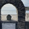
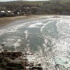
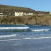
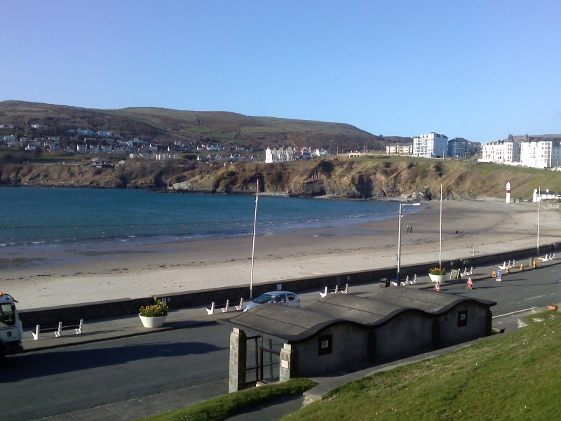
Port Erin Beach is a sandy bay enclosed by rocky headlands and backed by the town of Port Erin. The beach curves around the bay in a horseshoe-shape and faces west, making it an ideal spot to watch the sunset. The cliffs of Bradda Head tower above the north end of the beach, featuring a key-shaped monument that commemorates William Milner, a local philanthropist.
On clear days, it is possible to see the Irish coast and the Mourne Mountains in the distance from the beach. A promenade runs adjacent to the beach, and the small Victorian resort town of Port Erin offers a range of facilities. The beach itself is home to a picturesque whitewashed café, where visitors can stop to enjoy a cup of tea while taking in the views.
Port Erin Beach is adjacent to the Isle of Man Coastal Path.
Sand
| Today | |
|---|---|
| Chance of rain | 94% |
| Max temperature | 15°C |
| feels like | 15°C |
| Wind 22mph | |
| Max UV Index |
| Tonight | |
|---|---|
| Chance of rain | 59% |
| Min temperature | 10°C |
| feels like | 10°C |
| Wind 20mph |
The tide at Port Erin Beach is currently falling. Low tide will be at approximately 8:29 AM, and the next high tide will be at approximately 2:40 PM.
![]() Today's air pollution levels are forecast to be Low
Today's air pollution levels are forecast to be Low
There is parking by the beach, on Shore Road.
No lifeguard cover at this beach
Port Erin Railway Museum (0.2 miles)
Milner's Tower (0.8 miles)
Sound Visitor Centre (2 miles)
Craftworks Studio (4.4 miles)
The Old House of Keys (4.5 miles)
Nautical Museum (4.5 miles)
Ape Mann Adventure Park (6.8 miles)
Laser-Mayhem (6.8 miles)
All distances are approximate
just over a mile east-southeast as the seagull flies, around 2 miles by road.
around 2 miles east as the seagull flies, around 2 miles by road.
around 5 miles east as the seagull flies, around 6 miles by road.
around 6 miles east as the seagull flies, around 6 miles by road.
around 8 miles east as the seagull flies, around 10 miles by road.
around 10 miles east-northeast as the seagull flies, around 12 miles by road.
around 10 miles north-northeast as the seagull flies, around 15 miles by road.
around 10 miles north-northeast as the seagull flies, around 15 miles by road.
around 11 miles north-northeast as the seagull flies, around 16 miles by road.
around 12 miles east-northeast as the seagull flies, around 15 miles by road.
around 13 miles east-northeast as the seagull flies, around 15 miles by road.
around 13 miles east-northeast as the seagull flies, around 16 miles by road.
around 15 miles north-northeast as the seagull flies, around 19 miles by road.
around 16 miles north-northeast as the seagull flies, around 20 miles by road.
around 17 miles east-northeast as the seagull flies, around 19 miles by road.
around 18 miles east-northeast as the seagull flies, around 26 miles by road.
around 21 miles north-northeast as the seagull flies, around 26 miles by road.
around 23 miles northeast as the seagull flies, around 31 miles by road.
around 23 miles northeast as the seagull flies, around 29 miles by road.
Coordinates: 54°5'12"N 4°45'39"W
Mapcode: IMN 6S.V0T
What 3 Words: recycled.regulate.comb
Coordinates and location codes are for an approximate mid-point of the beach, and may not reflect the best access point or the most popular part of the beach.
County: Isle of Man
Country: Isle of Man
Important! Beach information is compiled from a variety of different sources and is correct to the best of our knowledge at the time of compilation. However, information may be incorrectly supplied by our sources or go out of date after publication. BritishBeaches.uk makes no warranty as to the accuracy of any information on this page.
(Or après-beach. Or pre-beach. Or, just because you might want stuff)
Men's Tops
Weird Fish Old Speckled Fin Back Print Artist T-Shirt Navy Size XL

Only £28.00 from Weird Fish