Approximate Location Map
Use two fingers to pan or zoom the map
Use two fingers to pan or zoom the map
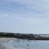
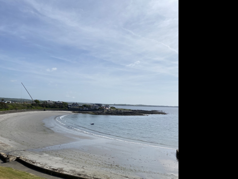
Port St Mary has a bustling harbour, predominantly occupied by yachts. Within the town, a small, sheltered sandy bay is nestled among rocky headlands and cliffs, providing a picturesque spot for visitors.
In close proximity to Port St Mary, Chapel Beach boasts a softly sloping sandy shoreline. The beach is situated in front of the promenade and seafront, ensuring that amenities are readily available.
As Chapel Beach is a popular destination, it offers a range of facilities to cater to visitors' needs. However, it is essential to note that dogs are prohibited from the beach during the summer months.
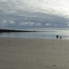
Port St. Mary Beach is adjacent to the Isle of Man Coastal Path.
Harbour Sand
| Today | |
|---|---|
| Chance of rain | 94% |
| Max temperature | 15°C |
| feels like | 15°C |
| Wind 22mph | |
| Max UV Index |
| Tonight | |
|---|---|
| Chance of rain | 67% |
| Min temperature | 10°C |
| feels like | 10°C |
| Wind 20mph |
The tide at Port St. Mary Beach is currently falling. Low tide will be at approximately 8:09 AM, and the next high tide will be at approximately 2:33 PM.
![]() Today's air pollution levels are forecast to be Low
Today's air pollution levels are forecast to be Low
There is a car park in the town, off The Promenade.
Dogs are allowed.
No lifeguard cover at this beach
Port Erin Railway Museum (1 miles)
Milner's Tower (2 miles)
Sound Visitor Centre (2.5 miles)
Craftworks Studio (3.4 miles)
The Old House of Keys (3.4 miles)
Nautical Museum (3.4 miles)
Rushen Abbey (4.3 miles)
All distances are approximate
less than a mile northeast as the seagull flies, just over a mile by road or less than a mile on foot using coastal paths.
just over a mile west-northwest as the seagull flies, just over a mile by road.
around 4 miles east as the seagull flies, around 5 miles by road.
around 5 miles east as the seagull flies, around 6 miles by road.
around 7 miles east-northeast as the seagull flies, around 9 miles by road.
around 9 miles east-northeast as the seagull flies, around 12 miles by road.
around 10 miles north as the seagull flies, around 15 miles by road.
around 10 miles north as the seagull flies, around 15 miles by road.
around 11 miles north-northeast as the seagull flies, around 16 miles by road.
around 12 miles east-northeast as the seagull flies, around 14 miles by road.
around 12 miles east-northeast as the seagull flies, around 14 miles by road.
around 13 miles east-northeast as the seagull flies, around 15 miles by road.
around 15 miles north-northeast as the seagull flies, around 19 miles by road.
around 16 miles north-northeast as the seagull flies, around 19 miles by road.
around 16 miles northeast as the seagull flies, around 19 miles by road.
around 17 miles northeast as the seagull flies, around 23 miles by road.
around 22 miles north-northeast as the seagull flies, around 26 miles by road.
around 22 miles northeast as the seagull flies, around 30 miles by road.
around 22 miles northeast as the seagull flies, around 28 miles by road.
Coordinates: 54°4'42"N 4°44'9"W
Mapcode: IMN 7T.FLZ
What 3 Words: eyebrow.croak.financier
Coordinates and location codes are for an approximate mid-point of the beach, and may not reflect the best access point or the most popular part of the beach.
County: Isle of Man
Country: Isle of Man
Important! Beach information is compiled from a variety of different sources and is correct to the best of our knowledge at the time of compilation. However, information may be incorrectly supplied by our sources or go out of date after publication. BritishBeaches.uk makes no warranty as to the accuracy of any information on this page.
(Or après-beach. Or pre-beach. Or, just because you might want stuff)
Men's Tops
Weird Fish Fished Branded T-Shirt Antique Moss Size M

Only £25.00 from Weird Fish