Approximate Location Map
Use two fingers to pan or zoom the map
Use two fingers to pan or zoom the map
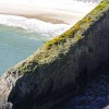
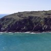
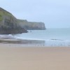
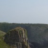
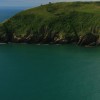
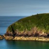
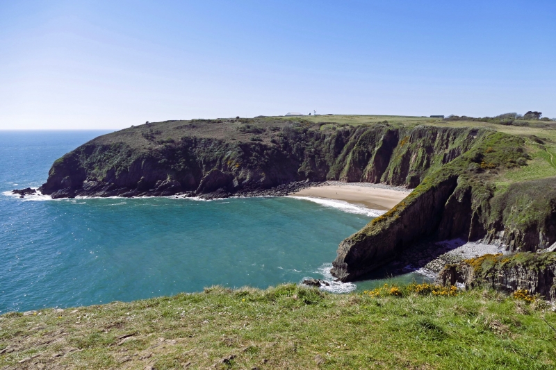
Skrinkle Haven beach sits between Old Castle Head and Lydstep Point and is located to the south-east of pretty Manorbier Village. The beach is a small rocky bay enclosed by high cliffs, with a wide expanse of soft golden sand exposed at low tide.
Access to the beach is via steep steps, which may be challenging for some visitors. Alternatively, there is a picturesque picnic site at the top of the pathway that allows visitors to take in the views over the bay. There are no facilities at the beach, and the nearest parking is at the Manorbier Youth Hostel close by.
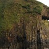
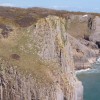
The beach is an area of important geological interest due to the limestone and red sandstone cliffs, which have created signature caves, blowholes, and chasms along the coastline. The area is also home to a wealth of local wildlife, making it a great destination for nature enthusiasts.
Around the headland on the east side of the beach, visitors can find the pretty Church Doors beach, which consists of a cove with several caves in the form of arches that resemble church doors. Although the two beaches are separated by a small limestone headland, it is possible to walk from one to the other when the tide is out.
Visitors should be aware that the beach was inaccessible for many years due to its proximity to the Royal Artillery Range, although military operations no longer take place. Additionally, when walking between Skrinkle Haven and Church Doors beach, visitors should be cautious of the incoming tide, as it is easy to get cut off.
Skrinkle Haven Beach is dog-friendly, and if visitors are walking the Pembrokeshire Coast Path, it takes a slight inland detour around the army facility behind the beach.
Cove Sand Rock
| Today | |
|---|---|
| Chance of rain | 99% |
| Max temperature | 15°C |
| feels like | 15°C |
| Wind 24mph | |
| Max UV Index |
| Tonight | |
|---|---|
| Chance of rain | 52% |
| Min temperature | 10°C |
| feels like | 11°C |
| Wind 24mph |
The tide at Skrinkle Beach is currently falling. Low tide will be at approximately 3:00 AM, and the next high tide will be at approximately 9:06 AM.
![]() Today's air pollution levels are forecast to be Low
Today's air pollution levels are forecast to be Low
Parking is a short (but steep) walk away.
Dogs are allowed.
No lifeguard cover at this beach
Water quality not measured here
Dyfed Cottage

From £650.00 per week at Holidaycottages.co.uk
Luxury Coastal Dyfed Boathouse

From £1086.00 per week at Holidaycottages.co.uk
Tremynydd Fawr

From £3578.00 per week at Sykes Holiday Cottages
Willow Lodge

From £2467.00 per week at Sykes Holiday Cottages
Coastal Dyfed Apartment
From £606.00 per week at Holidaycottages.co.uk
Harmon Vale

From £4723.00 per week at Sykes Holiday Cottages
The Spa at Celtic Haven (0.8 miles)
Manorbier Castle (1 miles)
Tenby Water Sports (1.5 miles)
Ritec Valley Quad Bikes (2.4 miles)
Heatherton World of Activities (3.3 miles)
Caldey Island (3.9 miles)
Tenby Fishing (4 miles)
Tenby Boat Trips (4.1 miles)
Tenby Lifeboat Station (4.1 miles)
All distances are approximate
less than a mile northeast as the seagull flies, around 3 miles by road or just over a mile on foot using coastal paths.
just over a mile west as the seagull flies, around 2 miles by road.
around 2 miles west as the seagull flies, around 4 miles by road or 3 miles on foot using coastal paths.
around 3 miles east-northeast as the seagull flies, around 4 miles by road.
around 3 miles east-northeast as the seagull flies, around 7 miles by road or 5 miles on foot using coastal paths.
around 4 miles west as the seagull flies, around 8 miles by road or 5 miles on foot using coastal paths.
around 4 miles east as the seagull flies, around 4 miles by road.
around 4 miles northeast as the seagull flies, around 6 miles by road.
around 4 miles east-northeast as the seagull flies, around 6 miles by road.
around 5 miles northeast as the seagull flies, around 7 miles by road.
around 6 miles northeast as the seagull flies, around 8 miles by road.
around 6 miles west-southwest as the seagull flies, around 10 miles by road or 8 miles on foot using coastal paths.
around 6 miles northeast as the seagull flies, around 9 miles by road.
around 6 miles northeast as the seagull flies, around 10 miles by road.
around 6 miles northeast as the seagull flies, around 10 miles by road.
around 7 miles west-southwest as the seagull flies, around 14 miles by road or 9 miles on foot using coastal paths.
around 7 miles northeast as the seagull flies, around 11 miles by road.
around 8 miles northeast as the seagull flies, around 13 miles by road.
around 8 miles west-northwest as the seagull flies, around 13 miles by road.
around 11 miles northeast as the seagull flies, around 17 miles by road.
Location: Lydstep
Location type: Village
OS Grid: SS079973
Coordinates: 51°38'30"N 4°46'37"W
Mapcode: GBR GC.VFYC
What 3 Words: coverings.sized.buns
Coordinates and location codes are for an approximate mid-point of the beach, and may not reflect the best access point or the most popular part of the beach.
Country: Wales
Local Authority: Pembrokeshire
Parish: Manorbier
Nearest postcode: SA70 7TT
(for sat-nav purposes only, a beach does not have a postal address!)
Important! Beach information is compiled from a variety of different sources and is correct to the best of our knowledge at the time of compilation. However, information may be incorrectly supplied by our sources or go out of date after publication. BritishBeaches.uk makes no warranty as to the accuracy of any information on this page.
(Or après-beach. Or pre-beach. Or, just because you might want stuff)
Men's Tops
Weird Fish Topaz Branded Pop Over Hoodie Navy Size 20

Only £27.50 from Weird Fish