Approximate Location Map
Use two fingers to pan or zoom the map
Use two fingers to pan or zoom the map
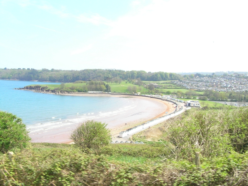
Broadsands beach is situated between rocky headlands, providing a safe and sheltered area for beachgoers. The beach boasts a gently sloping gradient, making it an ideal spot for families with children. The red sandy beach is backed by parkland and features a long promenade lined with colourful beach huts, offering a level walk to both ends of the beach.
The beach offers a range of facilities, including cafes, restaurants, shops, and toilets (including disabled facilities). Visitors can enjoy a variety of activities, such as kayaking, paddleboarding, paddling, sailing, and swimming in the calm waters. The beach is also perfect for rock pooling, sandcastle building, and playing sports like football on the grass behind the beach. Dogs on leads can be exercised on the grass, although they are not permitted on the beach during the summer season (May to September).
The beach has a large pay and display car park, and bus number 12 stops nearby. Access to the beach is via stairs with handrails, although a beach wheelchair is available for hire on a daily basis. There are also shower facilities, a first aid room, and picnic sites available. Unisex toilets are available for a small fee.
The beach offers stunning views of the Paignton to Dartmouth Steam Railway viaduct in the hills and is located near a Neolithic tomb on the hillside overlooking the beach.
The beach is a popular spot for families during the summer season, with deckchairs, pedalos, and boats available for hire on sunny days. Dog owners should note that dogs are restricted on the beach during the summer months (1 May to 30 September).
Broadsands is adjacent to the South West Coast Path.
Sand Pebbles
| Tonight |  |
|---|---|
| Chance of rain | 91% |
| Min temperature | 12°C |
| feels like | 10°C |
| Wind 19mph |  |
| Tomorrow |
|
|---|---|
| Chance of rain | 100% |
| Max temperature | 17°C |
| feels like | 12°C |
| Wind 31mph |  |
| Max UV Index |  |
The tide at Broadsands is currently falling. Low tide will be at approximately 11:43 PM, and the next high tide will be at approximately 6:06 AM tomorrow.
Detailed weather and tides » Food available
 Toilets
 Litter bins
 Slipway
There is a car park adjacent to the beach.
Dogs not allowed May 1st to September 30th.
Beach manually and mechanically cleaned daily during the summer
No lifeguard cover at this beach



Water quality not measured here
less than a mile southeast as the seagull flies, less than a mile by road or less than a mile on foot using coastal paths.
just over a mile north as the seagull flies, around 3 miles by road or 2 miles on foot using coastal paths.
just over a mile east as the seagull flies, around 4 miles by road or 2 miles on foot using coastal paths.
around 2 miles north as the seagull flies, around 4 miles by road or 3 miles on foot using coastal paths.
around 2 miles east as the seagull flies, around 4 miles by road or 3 miles on foot using coastal paths.
around 3 miles east-southeast as the seagull flies, around 4 miles by road or 3 miles on foot using coastal paths.
around 3 miles north as the seagull flies, around 4 miles by road or 3 miles on foot using coastal paths.
around 3 miles north as the seagull flies, around 4 miles by road.
around 3 miles southeast as the seagull flies, around 7 miles by road or 4 miles on foot using coastal paths.
around 4 miles north-northeast as the seagull flies, around 6 miles by road.
around 4 miles north as the seagull flies, around 6 miles by road.
around 4 miles north-northeast as the seagull flies, around 7 miles by road.
around 5 miles north-northeast as the seagull flies, around 8 miles by road.
around 5 miles north-northeast as the seagull flies, around 8 miles by road.
around 5 miles north-northeast as the seagull flies, around 8 miles by road.
around 6 miles north-northeast as the seagull flies, around 8 miles by road.
around 6 miles north-northeast as the seagull flies, around 10 miles by road.
around 7 miles north-northeast as the seagull flies, around 9 miles by road.
around 9 miles north-northeast as the seagull flies, around 12 miles by road.
around 9 miles north-northeast as the seagull flies, around 12 miles by road.
Location: Broadsands, Paignton
Location type: Urban
OS Grid: SX896574
Coordinates: 50°24'23"N 3°33'14"W
Mapcode: GBR QT.TY84
What 3 Words: join.supposes.adopt
Coordinates and location codes are for an approximate mid-point of the beach, and may not reflect the best access point or the most popular part of the beach.
Country: England
Local Authority: Torbay
Nearest postcode: TQ4 6HL
(for sat-nav purposes only, a beach does not have a postal address!)
Important! Beach information is compiled from a variety of different sources and is correct to the best of our knowledge at the time of compilation. However, information may be incorrectly supplied by our sources or go out of date after publication. BritishBeaches.uk makes no warranty as to the accuracy of any information on this page.