Approximate Location Map
Use two fingers to pan or zoom the map
Use two fingers to pan or zoom the map
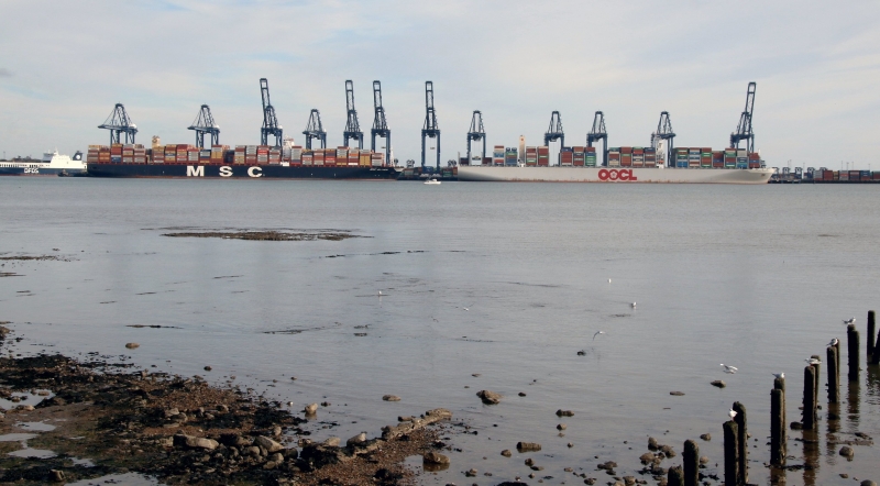
Beacon Hill Beach is situated just south of Beacon Hill fort, a derelict defence fort facing south-east. The estuary has been fortified since Roman times, and the fort last saw service as coastal artillery defence during World War II. The beach stretches down from Beacon Cliffs in a south-westerly direction, just to the south of the estuaries of the Stour and Orwell rivers, and offers views towards the cranes and industrial buildings of Felixstowe.
The beach has a number of beach huts lining the seafront, and The Waterfront is located further south along the beach, offering a place to eat. At the southern end of the beach, the promenade loops round Cornwallis Battery to join Dovercourt beach to the east. The solitary buildings of Beacon Hill Fort can be found at the north-eastern end of the beach, which has been a fortified site since the time of Henry VIII.
Today, most of the remains of the fort are inaccessible, but the former radar tower is generally open to the public in summer, for a small entrance fee, on one Sunday each month.
Shingle
| Today | |
|---|---|
| Chance of rain | 80% |
| Max temperature | 17°C |
| feels like | 17°C |
| Wind 20mph | |
| Max UV Index |
| Tonight | |
|---|---|
| Chance of rain | 35% |
| Min temperature | 11°C |
| feels like | 12°C |
| Wind 17mph |
The tide at Harwich Beacon Hill Beach is currently falling. Low tide will be at approximately 8:20 AM, and the next high tide will be at approximately 2:47 PM.
![]() Today's air pollution levels are forecast to be Low
Today's air pollution levels are forecast to be Low
There are various parking options near the port and in the town, off Marine Parade.
No lifeguard cover at this beach
![]()
Water quality not measured here
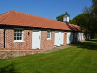
Essex Stables
From £494.00 per week at Holidaycottages.co.uk
Two Chantry Barns, Orford

From £2764.00 per week at Sykes Holiday Cottages
Shepherds Pightle

From £1273.00 per week at Sykes Holiday Cottages
Hartlands, Aldeburgh

From £5005.00 per week at Sykes Holiday Cottages
Stable Cottage at the Grove, Great Glemham

From £2967.00 per week at Sykes Holiday Cottages
Betsy (Cow Shed 2)

From £875.00 per week at Sykes Holiday Cottages
Harwich Redoubt Fort (0.1 miles)
Electric Palace (0.4 miles)
Halfpenny Pier (0.6 miles)
Lightvessel LV18 (0.6 miles)
Landguard Fort (1.3 miles)
Felixstowe Museum (1.5 miles)
Stena Line (1.8 miles)
Felixstowe Seafront Gardens (2.8 miles)
Port of Felixstowe (3.1 miles)
Treo Bar Cafe (430 yards)
Thai Up At The Quay (230 yards)
The Alma Inn and Dining Rooms (200 yards)
The Cafe on the Pier (150 yards)
All distances are approximate
less than a mile northwest as the seagull flies, less than a mile by road or less than a mile on foot using coastal paths.
less than a mile southwest as the seagull flies, less than a mile by road.
around 6 miles south as the seagull flies, around 15 miles by road.
around 8 miles south-southwest as the seagull flies, around 15 miles by road.
around 9 miles south-southwest as the seagull flies, around 15 miles by road.
around 11 miles south-southwest as the seagull flies, around 18 miles by road.
around 12 miles south-southwest as the seagull flies, around 19 miles by road.
around 13 miles south-southwest as the seagull flies, around 19 miles by road.
around 14 miles south-southwest as the seagull flies, around 20 miles by road.
around 15 miles southwest as the seagull flies, around 19 miles by road.
around 2 miles east-northeast as the seagull flies, around 32 miles by road or 4 miles on foot using coastal paths.
around 3 miles east-northeast as the seagull flies, around 32 miles by road or 5 miles on foot using coastal paths.
around 20 miles southwest as the seagull flies, around 27 miles by road.
around 20 miles northeast as the seagull flies, around 48 miles by road or 29 miles on foot using coastal paths.
around 27 miles north-northeast as the seagull flies, around 54 miles by road or 35 miles on foot using coastal paths.
around 31 miles north-northeast as the seagull flies, around 59 miles by road or 39 miles on foot using coastal paths.
Location: Bath Side, Harwich
Location type: Urban
OS Grid: TM262320
Coordinates: 51°56'25"N 1°17'26"E
Mapcode: GBR VQR.950
What 3 Words: catch.smug.divorcing
Coordinates and location codes are for an approximate mid-point of the beach, and may not reflect the best access point or the most popular part of the beach.
County: Essex
Country: England
Local Authority: Tendring
Parish: Harwich
Nearest postcode: CO12 3NP
(for sat-nav purposes only, a beach does not have a postal address!)
Important! Beach information is compiled from a variety of different sources and is correct to the best of our knowledge at the time of compilation. However, information may be incorrectly supplied by our sources or go out of date after publication. BritishBeaches.uk makes no warranty as to the accuracy of any information on this page.
(Or après-beach. Or pre-beach. Or, just because you might want stuff)
Men's Tops
Weird Fish Newark 1/4 Zip Grid Fleece Brick Orange Size XL

Only £30.00 from Weird Fish