Approximate Location Map
Use two fingers to pan or zoom the map
Use two fingers to pan or zoom the map
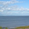
Walney Island, an 11-mile long island in the Irish Sea, is located at the tip of the Furness peninsula and linked to the mainland town of Barrow-in-Furness by the toll-free Jubilee bridge. The island features a variety of landscapes, including sandy beaches at its northern end and a nature reserve.
The island is home to two nature reserves, both administered by the Cumbria Wildlife Trust. The reserve at South Walney serves as a stop-off point for migratory birds and is home to Cumbria's only colony of grey seals. Additionally, the island boasts unique plant life, including the pale pink Walney Geranium.
Piel Island, located at the south-east end of Walney Island, features the ruins of a 14th-century castle and holds historical significance as the landing site of Lambert Simnel, a pretender to King Henry VII's throne, in 1487.
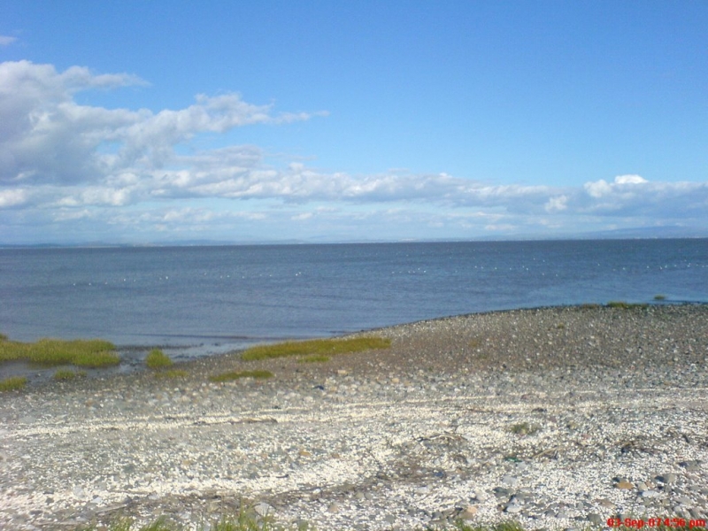
Earnse Bay, a picturesque sand and shingle beach on the western side of Walney Island, offers stunning panoramic views of the Irish Sea, the Isle of Man, and the Lake District mountains. The beach is a popular destination for walkers, sunbathers, and kitesurfers, and is also home to the North West Kitesurfing surf school.
The northern end of Walney Island features a long sandy beach backed by an expanse of dunes forming a nature reserve, with the far north used by naturists. The beach and surrounding habitats support a diverse range of flora and fauna, making it a great spot for nature enthusiasts.
Regular bus services connect Earnse Bay to the surrounding areas, and it is accessible via Jubilee Bridge, linking it to Barrow on the mainland. The beach is adjacent to the Furness Golf Club and West Shore Park, a residential complex.
Sand Shingle Mud
| Today | |
|---|---|
| Chance of rain | 100% |
| Max temperature | 15°C |
| feels like | 15°C |
| Wind 25mph | |
| Max UV Index |
| Tonight | |
|---|---|
| Chance of rain | 96% |
| Min temperature | 11°C |
| feels like | 10°C |
| Wind 22mph |
The tide at Barrow-in-Furness Beach is currently falling. Low tide will be at approximately 8:54 AM, and the next high tide will be at approximately 2:41 PM.
![]() Today's air pollution levels are forecast to be Low
Today's air pollution levels are forecast to be Low
Dogs are allowed.
No lifeguard cover at this beach
Water quality not measured here
Luxury Quirky Lancashire House
From £2159.00 per week at Holidaycottages.co.uk
Rural Cumbria House Cottage
From £658.00 per week at Holidaycottages.co.uk
Bishop Fell

From £4572.00 per week at Sykes Holiday Cottages
Foxrock

From £5246.00 per week at Sykes Holiday Cottages
Goswick Hall

From £1782.00 per week at Sykes Holiday Cottages
Romantic Rural Cumbria Lodge
From £651.00 per week at Holidaycottages.co.uk
Earnse Bay (0.4 miles)
The Dock Museum (1.1 miles)
Little Subs (1.1 miles)
Barrow Park (1.3 miles)
The Forum (1.4 miles)
Barrow-in-Furness Library (1.6 miles)
Escape Room (1.6 miles)
Furness Abbey (2 miles)
Sandscale Haws National Nature Reserve (3 miles)
Crown (220 yards)
All distances are approximate
just over a mile west-southwest as the seagull flies, around 4 miles by road or 2 miles on foot using coastal paths.
around 2 miles south-southwest as the seagull flies, around 3 miles by road or 2 miles on foot using coastal paths.
around 2 miles south-southwest as the seagull flies, around 3 miles by road.
around 3 miles north-northeast as the seagull flies, around 4 miles by road.
around 4 miles north-northeast as the seagull flies, around 6 miles by road.
around 5 miles north-northwest as the seagull flies, around 24 miles by road.
around 5 miles east as the seagull flies, around 9 miles by road.
around 6 miles north as the seagull flies, around 23 miles by road.
around 6 miles east as the seagull flies, around 10 miles by road.
around 7 miles east-northeast as the seagull flies, around 10 miles by road.
around 7 miles northwest as the seagull flies, around 24 miles by road.
around 14 miles east-northeast as the seagull flies, around 24 miles by road.
around 15 miles east-southeast as the seagull flies, around 52 miles by road.
around 15 miles east-southeast as the seagull flies, around 51 miles by road.
around 15 miles east-southeast as the seagull flies, around 50 miles by road.
around 16 miles east-southeast as the seagull flies, around 49 miles by road.
around 16 miles east-southeast as the seagull flies, around 49 miles by road.
around 17 miles north-northwest as the seagull flies, around 35 miles by road.
around 17 miles east-northeast as the seagull flies, around 34 miles by road.
around 18 miles east as the seagull flies, around 41 miles by road.
Location: Ormsgill, Barrow-in-Furness
Location type: Urban
OS Grid: SD186710
Coordinates: 54°7'42"N 3°14'44"W
Mapcode: GBR 5NSP.3T
What 3 Words: daily.curving.hood
Coordinates and location codes are for an approximate mid-point of the beach, and may not reflect the best access point or the most popular part of the beach.
County: Cumbria
Country: England
Local Authority: Barrow-in-Furness
Nearest postcode: LA14 5UY
(for sat-nav purposes only, a beach does not have a postal address!)
Important! Beach information is compiled from a variety of different sources and is correct to the best of our knowledge at the time of compilation. However, information may be incorrectly supplied by our sources or go out of date after publication. BritishBeaches.uk makes no warranty as to the accuracy of any information on this page.
(Or après-beach. Or pre-beach. Or, just because you might want stuff)
Men's Tops
Weird Fish Beye 1/4 Zip Grid Fleece Ecru Size 22

Only £45.00 from Weird Fish