Approximate Location Map
Use two fingers to pan or zoom the map
Use two fingers to pan or zoom the map
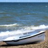
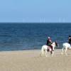
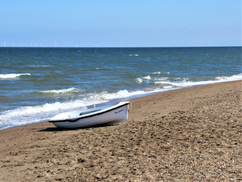
Moggs Eye Beach is a sandy beach surrounded by unspoilt countryside and sandhills, with unobtrusive steps leading over the dunes to Marsh Yard picnic area and car park. The beach is situated just north of Anderby Creek and offers a wide strip of golden sand that slopes gently into the sea. This makes it an ideal destination for various beach activities, including beach games, swimming, surfing, sea angling, and bird watching. The beach is also popular with walkers, who can enjoy a variety of good walks in the area.
The beach and its surroundings offer several facilities and activities. There is a car park with space for 150 cars, which also features toilets and a good picnic area. From the car park, steps lead over the dunes towards the beach. There are currently no restrictions on dog walking on the beach. Visitors can also enjoy views out towards an offshore windfarm. For those looking to indulge in refreshments, a cafe is available in Anderby Creek.
Moggs Eye Beach is located north of Chapel St. Leonards, near Anderby Creek, a popular seaside holiday destination. The area offers various accommodation options, including caravan sites, chalet parks, and holiday cottages, catering to different types of holidaymakers.
Sand
| Tonight | |
|---|---|
| Chance of rain | 49% |
| Min temperature | 11°C |
| feels like | 10°C |
| Wind 17mph |
| Tomorrow |
|
|---|---|
| Chance of rain | % |
| Max temperature | 17°C |
| feels like | 17°C |
| Wind 14mph | |
| Max UV Index |
The tide at Moggs Eye Beach is currently rising. High tide will be at approximately 9:42 PM, and the next low tide will be at approximately 3:56 AM tomorrow.
![]() Today's air pollution levels are forecast to be Low
Today's air pollution levels are forecast to be Low
Car parking in nearby Anderby Creek.
Dog restrictions apply.
Beach cleaned as required by council.
No lifeguard cover at this beach
![]()
Excellent water quality
19 The Court

From £2038.00 per week at Sykes Holiday Cottages
1 The Bays

From £1772.00 per week at Sykes Holiday Cottages
99 Cherry Park

From £1323.00 per week at Sykes Holiday Cottages
Romantic Lincolnshire Cottage
From £612.00 per week at Holidaycottages.co.uk
Lincolnshire Cottage

From £823.00 per week at Holidaycottages.co.uk
Rigsby With Ailby Stables
From £643.00 per week at Holidaycottages.co.uk
Anderby Creek (0.9 miles)
Sandilands Golf Club (2.1 miles)
Radcliffe Donkey Sanctuary (2.3 miles)
On Your Marques (2.7 miles)
Queens Park, Mablethorpe (3.2 miles)
Love Sweets (3.3 miles)
Sand Train (3.3 miles)
The Admiral Benbow (3.5 miles)
Northcote Heavy Horse Centre (3.5 miles)
Hardys Animal Farm (5 miles)
All distances are approximate
less than a mile south-southeast as the seagull flies, around 2 miles by road or just over a mile on foot using coastal paths.
around 3 miles north-northwest as the seagull flies, around 4 miles by road.
around 3 miles south-southeast as the seagull flies, around 4 miles by road.
around 5 miles north-northwest as the seagull flies, around 7 miles by road.
around 6 miles south-southeast as the seagull flies, around 8 miles by road.
around 9 miles south as the seagull flies, around 11 miles by road.
around 23 miles northwest as the seagull flies, around 32 miles by road.
around 24 miles northwest as the seagull flies, around 33 miles by road.
around 23 miles south-southeast as the seagull flies, around 82 miles by road.
around 24 miles south-southeast as the seagull flies, around 81 miles by road.
around 25 miles south-southeast as the seagull flies, around 81 miles by road.
around 26 miles south-southeast as the seagull flies, around 80 miles by road.
around 26 miles south-southeast as the seagull flies, around 79 miles by road.
around 28 miles south as the seagull flies, around 78 miles by road.
around 29 miles southeast as the seagull flies, around 92 miles by road.
around 30 miles southeast as the seagull flies, around 94 miles by road.
Location: Anderby Creek
Location type: Village
OS Grid: TF547774
Coordinates: 53°16'18"N 0°19'8"E
Mapcode: GBR ZZNL.WW
What 3 Words: sharpness.tribune.stared
Coordinates and location codes are for an approximate mid-point of the beach, and may not reflect the best access point or the most popular part of the beach.
County: Lincolnshire
Country: England
Local Authority: East Lindsey
Parish: Huttoft
Nearest postcode: PE24 5YQ
(for sat-nav purposes only, a beach does not have a postal address!)
Important! Beach information is compiled from a variety of different sources and is correct to the best of our knowledge at the time of compilation. However, information may be incorrectly supplied by our sources or go out of date after publication. BritishBeaches.uk makes no warranty as to the accuracy of any information on this page.
(Or après-beach. Or pre-beach. Or, just because you might want stuff)
Men's Tops
Weird Fish Carp Side Front Print Artist T-Shirt Deep Lichen Green Size XL

Only £28.00 from Weird Fish