Approximate Location Map
Use two fingers to pan or zoom the map
Use two fingers to pan or zoom the map
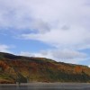
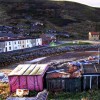
Cattersty Sands forms a long beach with rocks at either end and a long pier near Skinningrove. The beach is a sand and shingle beach, offering fine views and a fairly sheltered location. It is intersected by a concrete jetty, which dates back to the area's mining days. The jetty was built in 1886 for loading steamboats that transported iron ore to Middlesbrough.
The nearby Cleveland Ironstone Mining Museum makes an interesting detour and has a courtyard picnic area. The beach to the eastern side of the jetty is often referred to as Skinningrove. This part of Yorkshire has a long history of iron-ore mining. When the tide is out, a huge expanse of sand is exposed, and there are a few rock pools here and there.
The 109-mile long Cleveland Way walking route passes adjacent to the beach. Walkers along the Cleveland Way coastal path follow along the cliff top. Visitors can relax for the day or take a walk from Skinningrove beach to nearby Saltburn. There is free parking at Skinningrove beach and also at Saltburn parade.
The beach is part of a beautiful stretch of the Cleveland Way and is backed by a dune system at the base of the cliffs. On sunny days, bathers can be seen cooling off in the North Sea waters.
Skinningrove Beach is on the North Yorkshire & Cleveland Heritage Coast.
Sand
| Tonight | |
|---|---|
| Chance of rain | 38% |
| Min temperature | 11°C |
| feels like | 9°C |
| Wind 18mph |
| Tomorrow |
|
|---|---|
| Chance of rain | 18% |
| Max temperature | 15°C |
| feels like | 15°C |
| Wind 15mph | |
| Max UV Index |
The tide at Skinningrove Beach is currently falling. Low tide will be at approximately 1:11 AM tomorrow, and the next high tide will be at approximately 7:16 AM tomorrow.
![]() Today's air pollution levels are forecast to be Low
Today's air pollution levels are forecast to be Low
Dogs are welcome.
No lifeguard cover at this beach
Water quality not measured here
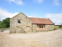
No. 2 Low Hall Cottages

From £1361.00 per week at Sykes Holiday Cottages
Blakey

From £1336.00 per week at Sykes Holiday Cottages
Rural North Yorkshire Cottage
From £646.00 per week at Holidaycottages.co.uk
The Lodge

From £5105.00 per week at Sykes Holiday Cottages
Green Tor

From £9869.00 per week at Sykes Holiday Cottages
Scalby Grove Cottage

From £2004.00 per week at Sykes Holiday Cottages
Cleveland Ironstone Mining Museum (0.8 miles)
Holey Molies (2.5 miles)
The Play Factory (2.6 miles)
Saltburn Miniature Railway Ltd (2.7 miles)
Flow Surf School (2.8 miles)
Saltburn Pier (2.8 miles)
Saltburn Cliff Tramway (2.8 miles)
Saltburn Surf School (2.9 miles)
All distances are approximate
around 3 miles west-northwest as the seagull flies, around 4 miles by road or 3 miles on foot using coastal paths.
around 5 miles east-southeast as the seagull flies, around 7 miles by road.
around 5 miles west-northwest as the seagull flies, around 8 miles by road or 6 miles on foot using coastal paths.
around 6 miles west-northwest as the seagull flies, around 9 miles by road or 7 miles on foot using coastal paths.
around 7 miles west-northwest as the seagull flies, around 10 miles by road or 8 miles on foot using coastal paths.
around 7 miles east-southeast as the seagull flies, around 9 miles by road.
around 7 miles west-northwest as the seagull flies, around 11 miles by road or 8 miles on foot using coastal paths.
around 8 miles west-northwest as the seagull flies, around 13 miles by road or 9 miles on foot using coastal paths.
around 11 miles east-southeast as the seagull flies, around 14 miles by road.
around 12 miles west-northwest as the seagull flies, around 28 miles by road.
around 13 miles west-northwest as the seagull flies, around 28 miles by road.
around 13 miles east-southeast as the seagull flies, around 16 miles by road.
around 14 miles west-northwest as the seagull flies, around 31 miles by road.
around 15 miles northwest as the seagull flies, around 35 miles by road.
around 16 miles northwest as the seagull flies, around 34 miles by road.
around 17 miles northwest as the seagull flies, around 35 miles by road.
around 18 miles east-southeast as the seagull flies, around 25 miles by road.
around 19 miles northwest as the seagull flies, around 36 miles by road.
around 20 miles northwest as the seagull flies, around 37 miles by road.
around 21 miles northwest as the seagull flies, around 37 miles by road.
Location: Skinningrove
Location type: Village
OS Grid: NZ710204
Coordinates: 54°34'28"N 0°54'9"W
Mapcode: GBR QH4J.DW
What 3 Words: masts.install.wordplay
Coordinates and location codes are for an approximate mid-point of the beach, and may not reflect the best access point or the most popular part of the beach.
Country: England
Local Authority: Redcar and Cleveland
Parish: Loftus
Nearest postcode: TS13 4BG
(for sat-nav purposes only, a beach does not have a postal address!)
Important! Beach information is compiled from a variety of different sources and is correct to the best of our knowledge at the time of compilation. However, information may be incorrectly supplied by our sources or go out of date after publication. BritishBeaches.uk makes no warranty as to the accuracy of any information on this page.
(Or après-beach. Or pre-beach. Or, just because you might want stuff)
Men's Tops
Weird Fish Fished Branded T-Shirt Fir Green Size L

Only £25.00 from Weird Fish