Approximate Location Map
Use two fingers to pan or zoom the map
Use two fingers to pan or zoom the map
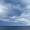
The bay is situated between Amble in the north and Creswell in the south, forming a seven-mile long stretch of coastline backed by an extensive dune system. The southern end of the bay, closest to Creswell, features a beach that has been recovering from its former use as a tipping site for mining waste. The beach is now becoming sandy, although evidence of its industrial past still remains.
The beach has several notable features, including the Alcan power plant to the south and Bog Hall point to the north. Access to the beach is available on foot from the main road via steep paths and from the car park at Bog Hall. The Blackemoor Burn runs into the sea at this point, attracting interesting bird life. A section of flat rocks, known as The Scars, lies just off the beach.
The beach is popular with walkers, watersport enthusiasts, and families who come to enjoy playing on the wide expanse of golden sand exposed at low tide. Parking is available on the coast road heading north out of Creswell, and there are nearby amenities, including an ice-cream shop and a café.
The bay is privately owned and includes a noted, though unofficial, nudist beach. A section of the bay is situated between the Northumberland Coast Country Park and the National Trust property.
Bay Sand Shingle Pebbles Rock
| Today | |
|---|---|
| Chance of rain | 82% |
| Max temperature | 15°C |
| feels like | 15°C |
| Wind 20mph | |
| Max UV Index |
| Tonight | |
|---|---|
| Chance of rain | 30% |
| Min temperature | 11°C |
| feels like | 11°C |
| Wind 19mph |
The tide at Lyne Mouth Bay is currently rising. High tide will be at approximately 6:21 AM, and the next low tide will be at approximately 12:47 PM.
![]() Today's air pollution levels are forecast to be Low
Today's air pollution levels are forecast to be Low
Small car park at the North end of the bay, with numerous "pull-ins" off the road that travels parallel with the beach.
No Dog restrictions
No lifeguard cover at this beach
Water quality not measured here
Wisteria Cottage

From £2157.00 per week at Sykes Holiday Cottages
Luxury Ulgham House
From £617.00 per week at Holidaycottages.co.uk
Romantic Northumberland Cottage
From £427.00 per week at Holidaycottages.co.uk
Low Croft

From £3370.00 per week at Sykes Holiday Cottages
Sunnybrae (Alnmouth)

From £2681.00 per week at Sykes Holiday Cottages
The Lodge (Alnwick)

From £2216.00 per week at Sykes Holiday Cottages
Queen Elizabeth II Country Park (1.9 miles)
Woodhorn Narrow Gauge Railway (2.3 miles)
Woodhorn Museum (2.4 miles)
Saint Bartholomew's Church (2.5 miles)
The Couple Statue (2.6 miles)
Newbiggin Maritime Centre (2.6 miles)
Druridge Bay Country Park (5.2 miles)
Stanton Hall Gardens and Nursery (5.7 miles)
All distances are approximate
just over a mile north-northwest as the seagull flies, around 2 miles by road.
just over a mile north-northwest as the seagull flies, around 2 miles by road.
around 2 miles south-southeast as the seagull flies, around 3 miles by road or 2 miles on foot using coastal paths.
around 2 miles south-southeast as the seagull flies, around 4 miles by road or 3 miles on foot using coastal paths.
around 3 miles south-southeast as the seagull flies, around 5 miles by road or 3 miles on foot using coastal paths.
around 3 miles north-northwest as the seagull flies, around 3 miles by road.
around 3 miles south as the seagull flies, around 6 miles by road or 4 miles on foot using coastal paths.
around 5 miles south as the seagull flies, around 9 miles by road or 7 miles on foot using coastal paths.
around 5 miles north-northwest as the seagull flies, around 11 miles by road or 6 miles on foot using coastal paths.
around 5 miles south as the seagull flies, around 9 miles by road or 7 miles on foot using coastal paths.
around 7 miles north as the seagull flies, around 12 miles by road or 8 miles on foot using coastal paths.
around 8 miles south as the seagull flies, around 13 miles by road.
around 9 miles north-northwest as the seagull flies, around 14 miles by road.
around 10 miles south-southeast as the seagull flies, around 15 miles by road.
around 12 miles north-northwest as the seagull flies, around 18 miles by road.
around 12 miles south-southeast as the seagull flies, around 18 miles by road.
around 13 miles south-southeast as the seagull flies, around 21 miles by road.
around 14 miles south-southeast as the seagull flies, around 21 miles by road.
around 14 miles south-southeast as the seagull flies, around 21 miles by road.
around 15 miles south-southeast as the seagull flies, around 21 miles by road.
Location: Lynemouth
Location type: Village
OS Grid: NZ300919
Coordinates: 55°13'16"N 1°31'42"W
Mapcode: GBR K8R2.V4
What 3 Words: oiled.hurt.relegate
Coordinates and location codes are for an approximate mid-point of the beach, and may not reflect the best access point or the most popular part of the beach.
Country: England
Local Authority: Northumberland
Parish: Cresswell
Nearest postcode: NE61 5UL
(for sat-nav purposes only, a beach does not have a postal address!)
Important! Beach information is compiled from a variety of different sources and is correct to the best of our knowledge at the time of compilation. However, information may be incorrectly supplied by our sources or go out of date after publication. BritishBeaches.uk makes no warranty as to the accuracy of any information on this page.
(Or après-beach. Or pre-beach. Or, just because you might want stuff)
Men's Tops
Weird Fish Pernille Organic Cotton Cutaway T-Shirt Navy Size 8

Only £14.00 from Weird Fish