Approximate Location Map
Use two fingers to pan or zoom the map
Use two fingers to pan or zoom the map
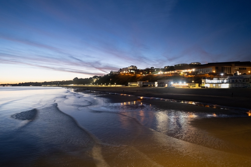
Bournemouth Pier Beach forms part of the 15 kilometre coastline of Poole Bay on the Dorset coast. The beach is approximately one kilometre wide and features a pier, restaurants, and amusements. It has been a favourite destination for beach-goers since Victorian times and remains one of Britain's most popular beaches.
The beach offers a wide range of facilities, including shops, cafes, amusement arcades, and an oceanarium. Visitors can also enjoy a variety of activities, such as taking a boat trip, stopping for lunch at one of the many restaurants, or simply taking a stroll down the pier. In the summer, regular firework festivals and night-time family festivals take place.
Bournemouth Central Beach is a traditional favourite for the whole family and brings thousands of visitors to the seaside resort town each summer. The wide sandy beach is perfect for getting out the bucket and spade. The beach is extremely clean, as is the sea, and the entire section of the Dorset coast has multiple Blue Flags, testament to the great range of facilities and outstanding cleanliness.
Bournemouth Pier was built in 1880 and stretches over 300 metres into the sea. It offers a mix of traditional and modern entertainment options, including the RockReef Adventure Centre with indoor climbing walls and an aerial obstacle course, and the PierZip, the world's first pier-to-shore zipline. There is also a café/restaurant, Key West Bar & Grill, which offers 360° views of the sea.
Bournemouth is known for having a slightly warmer microclimate with more sunshine than much of the UK, making it a go-to destination for sun-seekers. The beach is easily accessible, with a promenade backing all of Bournemouth's beaches, allowing for a leisurely stroll, a jog, or a bike ride. Visitors can also hop on the Bournemouth land train, which runs in the warmer months.
Bournemouth Pier Beach is adjacent to the Bournemouth Coast Path.
Bay Sand
| Today |  |
|---|---|
| Chance of rain | 100% |
| Max temperature | 12°C |
| feels like | 11°C |
| Wind 23mph |  |
| Max UV Index |  |
| Tonight |  |
|---|---|
| Chance of rain | 93% |
| Min temperature | 10°C |
| feels like | 9°C |
| Wind 17mph |  |
The tide at Bournemouth Pier Beach is currently falling. Low tide will be at approximately 1:24 PM, and the next high tide will be at approximately 7:03 PM.
 Today's air pollution levels are forecast to be Low
 Food available
 Toilets
 Shops
Shops
 Litter bins
Public car parks available adjacent to the seafront in Bournemouth. A small number of disabled spaces are available on the seafront to the East of Bournemouth Pier.
Dogs not allowed between May 1st and September 31st. Dog exercise areas during these months available in other areas.
Daily beach cleans during the summer and weekly during the winter.

Daily - 30th April - 25th September
Easter - 25th March - 10th April



Water quality not measured here
less than a mile east-northeast as the seagull flies, around 3 miles by road or less than a mile on foot using coastal paths.
less than a mile west-southwest as the seagull flies, less than a mile by road or less than a mile on foot using coastal paths.
less than a mile west-southwest as the seagull flies, around 2 miles by road or less than a mile on foot using coastal paths.
just over a mile east as the seagull flies, around 2 miles by road or 2 miles on foot using coastal paths.
around 2 miles west-southwest as the seagull flies, around 3 miles by road or 2 miles on foot using coastal paths.
around 2 miles east as the seagull flies, around 2 miles by road.
around 2 miles west-southwest as the seagull flies, around 3 miles by road or 2 miles on foot using coastal paths.
around 3 miles east as the seagull flies, around 3 miles by road.
around 3 miles west-southwest as the seagull flies, around 4 miles by road or 3 miles on foot using coastal paths.
around 3 miles west-southwest as the seagull flies, around 4 miles by road or 3 miles on foot using coastal paths.
around 3 miles southwest as the seagull flies, around 5 miles by road or 4 miles on foot using coastal paths.
around 4 miles east as the seagull flies, around 4 miles by road.
around 5 miles east as the seagull flies, around 5 miles by road.
around 6 miles east as the seagull flies, around 9 miles by road or 6 miles on foot using coastal paths.
around 6 miles west as the seagull flies, around 7 miles by road.
around 6 miles east as the seagull flies, around 9 miles by road.
around 7 miles west as the seagull flies, around 8 miles by road.
around 7 miles west as the seagull flies, around 8 miles by road.
around 25 miles east-northeast as the seagull flies, around 36 miles by road.
around 4 miles southwest as the seagull flies, around 6 miles by road.
Location: Bournemouth
Location type: Urban
OS Grid: SZ089906
Coordinates: 50°42'56"N 1°52'30"W
Mapcode: GBR X7P.6H
What 3 Words: scarf.burst.doors
Coordinates and location codes are for an approximate mid-point of the beach, and may not reflect the best access point or the most popular part of the beach.
Country: England
Local Authority: Bournemouth
Nearest postcode: BH2 5AA
(for sat-nav purposes only, a beach does not have a postal address!)
Important! Beach information is compiled from a variety of different sources and is correct to the best of our knowledge at the time of compilation. However, information may be incorrectly supplied by our sources or go out of date after publication. BritishBeaches.uk makes no warranty as to the accuracy of any information on this page.


