Approximate Location Map
Use two fingers to pan or zoom the map
Use two fingers to pan or zoom the map
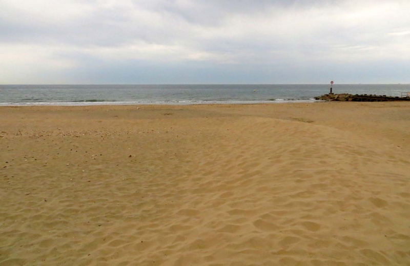
Bournemouth Manor Steps Beach is one of the quieter beaches in the Bournemouth area, situated to the east of Boscombe Pier. The beach is a sandy stretch with a number of wooden groynes extending into the sea, offering views of the white cliffs of Hengistbury Head. The beach is backed by low-rise, wooded cliffs.
The beach has a shop and kiosk providing snacks and beach accessories, as well as toilet facilities. Nearby Boscombe Pier has recently undergone a £2.4 million restoration and features a series of musical installations, "fish-friendly" mini-golf, and a promenade with an RNLI lookout. The promenade is a popular spot for bracing walks along the seafront and offers stunning coastal views.
For those looking to stay overnight, there are 15 attractively coloured beach huts, known as Bournemouth Beach Lodges, available for groups of up to six people. Pedestrian access to the beach is via a zig-zag pathway, which includes some steps, leading from Boscombe Overcliff Drive. Alternatively, the beach can be accessed from Fisherman’s Walk Cliff Lifts, which operate between Easter and the end of October.
There are plenty of good facilities nearby, including a number of restaurants and local amenities. The beach is close to Boscombe pier and Fisherman's Walk, making it an ideal location for those looking to enjoy the coastal scenery and amenities.
Bournemouth Manor Steps Beach is adjacent to the Bournemouth Coast Path.
Bay Sand
| Today |  |
|---|---|
| Chance of rain | 97% |
| Max temperature | 15°C |
| feels like | 15°C |
| Wind 19mph |  |
| Max UV Index |  |
| Tonight |  |
|---|---|
| Chance of rain | % |
| Min temperature | 9°C |
| feels like | 13°C |
| Wind 16mph | |
The tide at Bournemouth Manor Steps Beach is currently rising. High tide will be at approximately 8:01 AM, and the next low tide will be at approximately 2:09 PM.
 Today's air pollution levels are forecast to be Low
 Food available
 Toilets
 Shops
Shops
 Litter bins
Pay parking is available in public car parks in nearby Boscombe Pier, as well as on the overcliff.
Dogs not allowed between May 1st and September 31st. Dog exercise areas during these months available in other areas.
Daily beach cleans during the summer, weekly during the winter.

Daily - 9th July - 4th September

Water quality not measured here
less than a mile west as the seagull flies, less than a mile by road or less than a mile on foot using coastal paths.
less than a mile east as the seagull flies, less than a mile by road.
just over a mile west as the seagull flies, around 2 miles by road.
around 2 miles east as the seagull flies, around 2 miles by road.
around 2 miles west as the seagull flies, around 2 miles by road.
around 3 miles west-southwest as the seagull flies, around 3 miles by road.
around 3 miles east as the seagull flies, around 3 miles by road.
around 3 miles west-southwest as the seagull flies, around 5 miles by road or 3 miles on foot using coastal paths.
around 4 miles west-southwest as the seagull flies, around 5 miles by road or 4 miles on foot using coastal paths.
around 4 miles east as the seagull flies, around 6 miles by road or 4 miles on foot using coastal paths.
around 4 miles east as the seagull flies, around 6 miles by road.
around 4 miles west-southwest as the seagull flies, around 6 miles by road or 4 miles on foot using coastal paths.
around 5 miles west-southwest as the seagull flies, around 7 miles by road or 5 miles on foot using coastal paths.
around 5 miles west-southwest as the seagull flies, around 7 miles by road or 5 miles on foot using coastal paths.
around 5 miles west-southwest as the seagull flies, around 7 miles by road or 6 miles on foot using coastal paths.
around 8 miles west as the seagull flies, around 9 miles by road.
around 9 miles west as the seagull flies, around 10 miles by road.
around 9 miles west as the seagull flies, around 11 miles by road.
around 23 miles east-northeast as the seagull flies, around 36 miles by road.
around 4 miles east as the seagull flies, around 6 miles by road.
Location: Boscombe, Bournemouth
Location type: Urban
OS Grid: SZ120912
Coordinates: 50°43'13"N 1°49'49"W
Mapcode: GBR XFK.W3
What 3 Words: ruby.layers.boom
Coordinates and location codes are for an approximate mid-point of the beach, and may not reflect the best access point or the most popular part of the beach.
Country: England
Local Authority: Bournemouth
Nearest postcode: BH5 1LN
(for sat-nav purposes only, a beach does not have a postal address!)
Important! Beach information is compiled from a variety of different sources and is correct to the best of our knowledge at the time of compilation. However, information may be incorrectly supplied by our sources or go out of date after publication. BritishBeaches.uk makes no warranty as to the accuracy of any information on this page.