Approximate Location Map
Use two fingers to pan or zoom the map
Use two fingers to pan or zoom the map
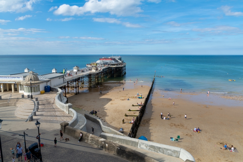
Cromer Beach is a sand and shingle beach backed by low sandy cliffs, with access to the traditional seaside town of Cromer via steps, ramps, and slopes. The beach supports a small fishing boat fleet, with crab boats launching from the beach and unloading their catch. At low tide, rock pools are revealed, making it an ideal spot for rock pooling.
A promenade runs along the main beach, providing access to Cromer town, pier, parking, toilets, and entertainment facilities. The beach is popular for swimming, surfing, and building sandcastles. The pier is a popular spot for sea angling, and surfing equipment and lessons are available. Beach facilities are good, with toilets, shops, food stands, and a slipway.
Cromer is a traditional Victorian seaside resort, with many buildings dating back to the Victorian era. The town originated as a fishing community and is still famous for its crabs and lobsters. The name "Cromer" is probably derived from "Crow's Mere". The beach has a Victorian Pier with a Pavilion Theatre and houses the offshore lifeboat, which performs a number of rescues every year.
Cromer Beach regularly earns a Blue Flag award, which means the water quality is high, the beach is clean, and safety measures are in place. Lifeguards are present in peak season, making it a safe choice for families with young children.
Beach parking is available at the cliff top car park, with access to the beach via a fairly steep slope or a lift connecting the town with the promenade and beach. The town centre is just a short walk from the seafront, with independent shops, cafes, and the RNLI Henry Blogg Museum.
From May to September, dogs aren't allowed on the main stretch of beach in front of the town. However, there are dog-friendly areas nearby, just follow the signs or ask a local.
Cromer Beach is adjacent to the Norfolk Coast Path.
Sand Shingle
| Today |  |
|---|---|
| Chance of rain | 92% |
| Max temperature | 11°C |
| feels like | 9°C |
| Wind 26mph |  |
| Max UV Index |  |
| Tonight |  |
|---|---|
| Chance of rain | 100% |
| Min temperature | 9°C |
| feels like | 4°C |
| Wind 29mph |  |
The tide at Cromer Beach is currently falling. Low tide will be at approximately 12:41 PM, and the next high tide will be at approximately 6:19 PM.
Detailed weather and tides » Food available
 Toilets
 Shops
Shops
 Litter bins
 Slipway
There is a cliff top car park. There is disabled parking on the promenade but the slope to the beach is steep although tarmacked.
Dogs not allowed May 1st to September 30th.
Beach cleaned daily during the summer.

Daily - 2nd July - 4th September



Water quality not measured here
less than a mile west-northwest as the seagull flies, just over a mile by road.
around 2 miles east-southeast as the seagull flies, around 3 miles by road.
around 2 miles west-northwest as the seagull flies, around 3 miles by road or 2 miles on foot using coastal paths.
around 4 miles west-northwest as the seagull flies, around 5 miles by road.
around 7 miles east-southeast as the seagull flies, around 8 miles by road.
around 11 miles west-northwest as the seagull flies, around 14 miles by road.
around 16 miles southeast as the seagull flies, around 22 miles by road.
around 19 miles west as the seagull flies, around 23 miles by road.
around 21 miles west as the seagull flies, around 24 miles by road.
around 24 miles southeast as the seagull flies, around 29 miles by road.
around 25 miles southeast as the seagull flies, around 30 miles by road.
around 27 miles southeast as the seagull flies, around 31 miles by road.
around 28 miles southeast as the seagull flies, around 32 miles by road.
around 29 miles southeast as the seagull flies, around 33 miles by road.
around 30 miles southeast as the seagull flies, around 34 miles by road.
around 30 miles southeast as the seagull flies, around 34 miles by road.
around 30 miles southeast as the seagull flies, around 35 miles by road.
Location: Cromer
Location type: Town
OS Grid: TG220423
Coordinates: 52°55'57"N 1°18'8"E
Mapcode: GBR WD3.041
What 3 Words: districts.prefect.earmarked
Coordinates and location codes are for an approximate mid-point of the beach, and may not reflect the best access point or the most popular part of the beach.
County: Norfolk
Country: England
Local Authority: North Norfolk
Parish: Cromer
Nearest postcode: NR27 9HE
(for sat-nav purposes only, a beach does not have a postal address!)
Important! Beach information is compiled from a variety of different sources and is correct to the best of our knowledge at the time of compilation. However, information may be incorrectly supplied by our sources or go out of date after publication. BritishBeaches.uk makes no warranty as to the accuracy of any information on this page.


