Approximate Location Map
Use two fingers to pan or zoom the map
Use two fingers to pan or zoom the map
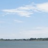
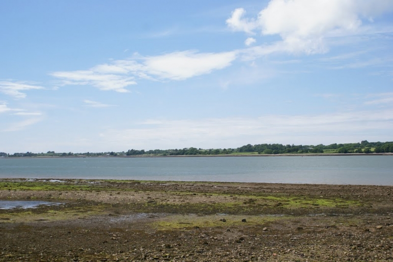
Plas Menai Beach is characterised by its mud and shingle shoreline along the eastern bank of the Menai Straits, offering views across to Anglesey. The beach is perhaps most notable for being the site of the Plas Menai national outdoor pursuits centre.
In contrast, Abermenai Beach, also known as Traeth Melynog, is a long sandy beach with views looking across towards Caernarfon. This beach is a spit rather than a traditional beach, comprising sand dunes and shingle that extends into the Menai Strait, marking the entrance to the strait from the southern tip of Anglesey. The dynamic geography of Abermenai Beach is shaped by tidal movements and sediment deposition, playing a significant role in the coastal ecosystem of the area.
Abermenai Beach is a great place to take the dog for a long walk, with paths across the dunes leading to Abermenai Point, the southernmost place in Anglesey. Visitors can explore the derelict ferry house and take in views of Fort Belan across the water. However, it is essential to time your visit for low tide, as some paths may be within tidal zones, and be cautious of the tides, as they can rise quickly and may make some areas impassable.
Shingle Mud
| Today | |
|---|---|
| Chance of rain | 89% |
| Max temperature | 16°C |
| feels like | 16°C |
| Wind 20mph | |
| Max UV Index |
| Tonight | |
|---|---|
| Chance of rain | 81% |
| Min temperature | 10°C |
| feels like | 11°C |
| Wind 17mph |
The tide at Plas Menai Beach is currently falling. Low tide will be at approximately 7:50 AM, and the next high tide will be at approximately 1:22 PM.
![]() Today's air pollution levels are forecast to be Low
Today's air pollution levels are forecast to be Low
Parking available at the centre.
No lifeguard cover at this beach
Water quality not measured here
Glasfryn

From £1795.00 per week at Sykes Holiday Cottages
Bryn Derwen

From £14465.00 per week at Sykes Holiday Cottages
Pen y Groes

From £1577.00 per week at Sykes Holiday Cottages
Old Barns - Pentre Berw

From £2772.00 per week at Sykes Holiday Cottages
Tri Raglan Bach

From £1612.00 per week at Sykes Holiday Cottages
11 Marine Terrace

From £7040.00 per week at Sykes Holiday Cottages
Anglesey Sea Salt Company - Halen Mon (1.5 miles)
Foel Farm Park (1.9 miles)
Celticos (1.9 miles)
GreenWood (Gelli Gyffwrdd) (2.1 miles)
Beacon Climbing Centre (2.3 miles)
Redline Indoor Karting (2.3 miles)
Caernarfon Castle (2.6 miles)
Anglesey Riding Centre (2.8 miles)
The Candle Alchemist (3.8 miles)
All distances are approximate
around 2 miles northeast as the seagull flies, around 2 miles by road.
around 5 miles northeast as the seagull flies, around 6 miles by road.
around 6 miles west-southwest as the seagull flies, around 17 miles by road.
around 7 miles south-southwest as the seagull flies, around 10 miles by road.
around 9 miles north-northeast as the seagull flies, around 13 miles by road.
around 9 miles west as the seagull flies, around 21 miles by road.
around 9 miles northeast as the seagull flies, around 11 miles by road.
around 9 miles south-southwest as the seagull flies, around 11 miles by road.
around 9 miles north as the seagull flies, around 13 miles by road.
around 10 miles north-northeast as the seagull flies, around 15 miles by road.
around 10 miles north as the seagull flies, around 14 miles by road.
around 10 miles north as the seagull flies, around 14 miles by road.
around 11 miles west-northwest as the seagull flies, around 22 miles by road.
around 11 miles northeast as the seagull flies, around 15 miles by road.
around 11 miles west-northwest as the seagull flies, around 22 miles by road.
around 11 miles west-northwest as the seagull flies, around 22 miles by road.
around 12 miles west-northwest as the seagull flies, around 22 miles by road.
around 12 miles east-northeast as the seagull flies, around 15 miles by road.
around 12 miles west-northwest as the seagull flies, around 22 miles by road.
around 13 miles north as the seagull flies, around 17 miles by road.
Location: Y Wern,
Location type: Rural
OS Grid: SH501660
Coordinates: 53°10'14"N 4°14'35"W
Mapcode: GBR 5K.47Q8
What 3 Words: corrupted.allow.richest
Coordinates and location codes are for an approximate mid-point of the beach, and may not reflect the best access point or the most popular part of the beach.
Country: Wales
Local Authority: Gwynedd
Parish: Y Felinheli
Nearest postcode: LL55 1UE
(for sat-nav purposes only, a beach does not have a postal address!)
Important! Beach information is compiled from a variety of different sources and is correct to the best of our knowledge at the time of compilation. However, information may be incorrectly supplied by our sources or go out of date after publication. BritishBeaches.uk makes no warranty as to the accuracy of any information on this page.
(Or après-beach. Or pre-beach. Or, just because you might want stuff)
Men's Tops
Weird Fish Fabian Striped Pique Polo Shirt Midnight Size 4XL

Only £22.50 from Weird Fish