Approximate Location Map
Use two fingers to pan or zoom the map
Use two fingers to pan or zoom the map
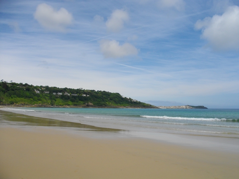
Carbis Bay Beach is a 25-acre stretch of golden sand, approximately one mile in length, backed by an expanse of sand dunes. The beach is privately owned by the Carbis Bay Hotel & Spa, which manages the beach and its facilities daily. The hotel, with its extensive grounds, is situated at the centre of the beach, providing stunning views across St Ives Bay.
The beach is generally sheltered, making it an ideal spot for families, and is usually Lifeguard protected during the summer months. The centre of the beach is home to the main facilities, including a car park, while the beach itself meanders away to rocky edges at either end. At low tide, the east side of the beach can dry out, connecting with the RSPB bird sanctuary beach of Porthkidney Sands, adding another mile and a half to the beach.
Located one mile east of St Ives, Carbis Bay is one of a line of sandy beaches that hug the coast from St Ives to Godrevy. The beach is served by the picturesque St Ives branch line, providing easy access for visitors. The coastal footpath runs along the back of the beach, allowing for scenic walks while avoiding the risk of being cut off by the tide.
Watersports are restricted on the beach, ensuring a family-friendly environment. Visitors should note that there are some restrictions in place during the summer months to ensure the safety and enjoyment of all beachgoers. However, the beach is dog-friendly between October 1st and April 30th, making it a great destination for pet owners.
The Carbis Bay area offers a range of accommodation options, from cozy bed and breakfasts to luxury hotels and self-catering vacation rentals, catering to various budgets and needs.
Carbis Bay is adjacent to the South West Coast Path.
Sand
| Tonight |  |
|---|---|
| Chance of rain | 67% |
| Min temperature | 15°C |
| feels like | 15°C |
| Wind 19mph |  |
| Tomorrow |
 |
|---|---|
| Chance of rain | 51% |
| Max temperature | 14°C |
| feels like | 17°C |
| Wind 26mph | |
| Max UV Index |  |
The tide at Carbis Bay is currently falling. Low tide will be at approximately 9:36 PM, and the next high tide will be at approximately 3:29 AM tomorrow.
 Today's air pollution levels are forecast to be Low
 Food available
 Toilets
 Shops
Shops
 Litter bins
 Slipway
Pay parking during the Summer and free parking out of season.
Dogs are not allowed on the beach from the first Sunday before Easter to 30th September, when a seasonal dog ban is in place.
Cleaned manually at regular intervals.

Daily - 9th July - 4th September



Water quality not measured here
less than a mile east-southeast as the seagull flies, less than a mile by road.
less than a mile northwest as the seagull flies, around 3 miles by road or less than a mile on foot using coastal paths.
just over a mile north-northwest as the seagull flies, around 6 miles by road or 2 miles on foot using coastal paths.
just over a mile northwest as the seagull flies, around 6 miles by road or 2 miles on foot using coastal paths.
around 2 miles east as the seagull flies, around 7 miles by road or 5 miles on foot using coastal paths.
around 2 miles east-northeast as the seagull flies, around 7 miles by road.
around 3 miles east-northeast as the seagull flies, around 7 miles by road.
around 3 miles east-northeast as the seagull flies, around 8 miles by road.
around 3 miles east-northeast as the seagull flies, around 8 miles by road.
around 4 miles northeast as the seagull flies, around 8 miles by road.
around 5 miles west as the seagull flies, around 8 miles by road.
around 5 miles south as the seagull flies, around 7 miles by road.
around 5 miles south as the seagull flies, around 7 miles by road.
around 5 miles west as the seagull flies, around 9 miles by road.
around 6 miles south-southwest as the seagull flies, around 8 miles by road.
around 6 miles south-southwest as the seagull flies, around 8 miles by road.
around 6 miles south as the seagull flies, around 10 miles by road or 8 miles on foot using coastal paths.
around 6 miles west as the seagull flies, around 10 miles by road.
around 7 miles south-southwest as the seagull flies, around 9 miles by road.
around 7 miles south-southwest as the seagull flies, around 10 miles by road.
Location: Carbis Bay
Location type: Town
OS Grid: SW528389
Coordinates: 50°11'54"N 5°27'52"W
Mapcode: GBR DXW5.3NZ
What 3 Words: optimists.outer.grounding
Coordinates and location codes are for an approximate mid-point of the beach, and may not reflect the best access point or the most popular part of the beach.
Country: England
Local Authority: Cornwall
Parish: St. Ives
Nearest postcode: TR26 2NN
(for sat-nav purposes only, a beach does not have a postal address!)
Important! Beach information is compiled from a variety of different sources and is correct to the best of our knowledge at the time of compilation. However, information may be incorrectly supplied by our sources or go out of date after publication. BritishBeaches.uk makes no warranty as to the accuracy of any information on this page.