Approximate Location Map
Use two fingers to pan or zoom the map
Use two fingers to pan or zoom the map
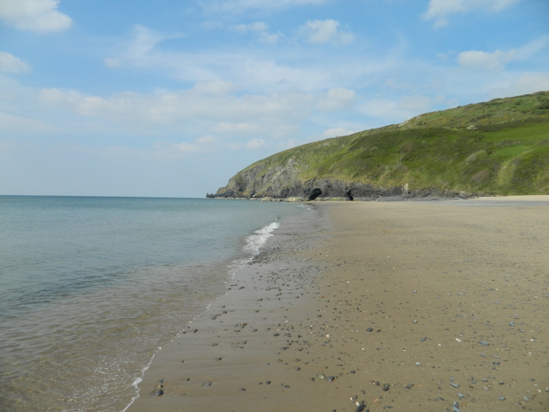
Penbryn Beach is a large, sandy beach backed by a dune system and cliffs, operated by the National Trust. The beach is a favourite among young families and bathers in the summer, and is also popular with surfers, canoeists, and kayakers. A small stream, known as the Nant Hoffnant, runs across the beach.
The beach is made up of soft, powdery sands that stretch for about a mile, and is generally sheltered from the wind due to the surrounding sloping woodlands. This makes it an ideal spot for families, who can enjoy making sandcastles or sunbathing. The gentle slope of the beach also makes it suitable for swimming, although there is no lifeguard service. There are several ways to access the beach, including a lane that leads to the central car park and Llanborth Farm, or by walking along a scenic path through the flowery woodlands.
The area surrounding Penbryn Beach has an interesting history, having been a route for smugglers in the past, and was also home to the pre-Roman tribe known as the Corbalengus. The beach is located between the scenic coves of Tresaith and Llangrannog, and is part of the Wales Coast Path. Penbryn Beach has won several awards for its cleanliness and natural beauty.
The beach is a popular stop-off point for walkers using the Ceredigion coastal path, and there are many caravan parks in the area offering a range of facilities. Visitors can also enjoy coastal walking along the cliffs with panoramic seascapes. At low tide, the beach reveals rock pools that are perfect for children and families to explore, providing opportunities to discover marine life.
Penbryn Beach was used as a location for the James Bond film “Die Another Day”.
Penbryn Beach is adjacent to the Ceredigion Coast Path and the Wales Coast Path.
Sand
| Today |  |
|---|---|
| Chance of rain | 100% |
| Max temperature | 15°C |
| feels like | 16°C |
| Wind 33mph |  |
| Tonight |  |
|---|---|
| Chance of rain | 100% |
| Min temperature | 10°C |
| feels like | 8°C |
| Wind 36mph |  |
The tide at Penbryn Beach is currently rising. High tide will be at approximately 7:15 PM, and the next low tide will be at approximately 1:58 AM tomorrow.
Detailed weather and tides » Campsite
 Food available
 Toilets
There is a National Trust car park and cafe near the beach.
Dog restrictions apply in the summer.
No lifeguard cover at this beach

Excellent water quality
just over a mile southwest as the seagull flies, around 2 miles by road.
around 2 miles northeast as the seagull flies, around 3 miles by road.
around 2 miles northeast as the seagull flies, around 3 miles by road.
around 2 miles west-southwest as the seagull flies, around 4 miles by road.
around 5 miles northeast as the seagull flies, around 7 miles by road.
around 6 miles west as the seagull flies, around 9 miles by road.
around 8 miles northeast as the seagull flies, around 13 miles by road or 10 miles on foot using coastal paths.
around 8 miles northeast as the seagull flies, around 14 miles by road or 9 miles on foot using coastal paths.
around 8 miles northeast as the seagull flies, around 13 miles by road or 10 miles on foot using coastal paths.
around 8 miles northeast as the seagull flies, around 13 miles by road or 9 miles on foot using coastal paths.
around 8 miles west-southwest as the seagull flies, around 13 miles by road.
around 8 miles west-southwest as the seagull flies, around 12 miles by road.
around 8 miles northeast as the seagull flies, around 12 miles by road.
around 9 miles northeast as the seagull flies, around 12 miles by road.
around 9 miles west-southwest as the seagull flies, around 11 miles by road.
around 9 miles west-southwest as the seagull flies, around 13 miles by road.
around 10 miles northeast as the seagull flies, around 14 miles by road.
around 12 miles northeast as the seagull flies, around 15 miles by road.
around 12 miles northeast as the seagull flies, around 15 miles by road.
around 13 miles northeast as the seagull flies, around 15 miles by road.
Location: Penbryn
Location type: Rural
Nearest village: Tresaith
OS Grid: SN292525
Coordinates: 52°8'40"N 4°29'49"W
Mapcode: GBR D6.735P
What 3 Words: chief.easily.rooks
Coordinates and location codes are for an approximate mid-point of the beach, and may not reflect the best access point or the most popular part of the beach.
Country: Wales
Local Authority: Ceredigion
Parish: Penbryn
Nearest postcode: SA44 6QL
(for sat-nav purposes only, a beach does not have a postal address!)
Important! Beach information is compiled from a variety of different sources and is correct to the best of our knowledge at the time of compilation. However, information may be incorrectly supplied by our sources or go out of date after publication. BritishBeaches.uk makes no warranty as to the accuracy of any information on this page.