Approximate Location Map
Use two fingers to pan or zoom the map
Use two fingers to pan or zoom the map
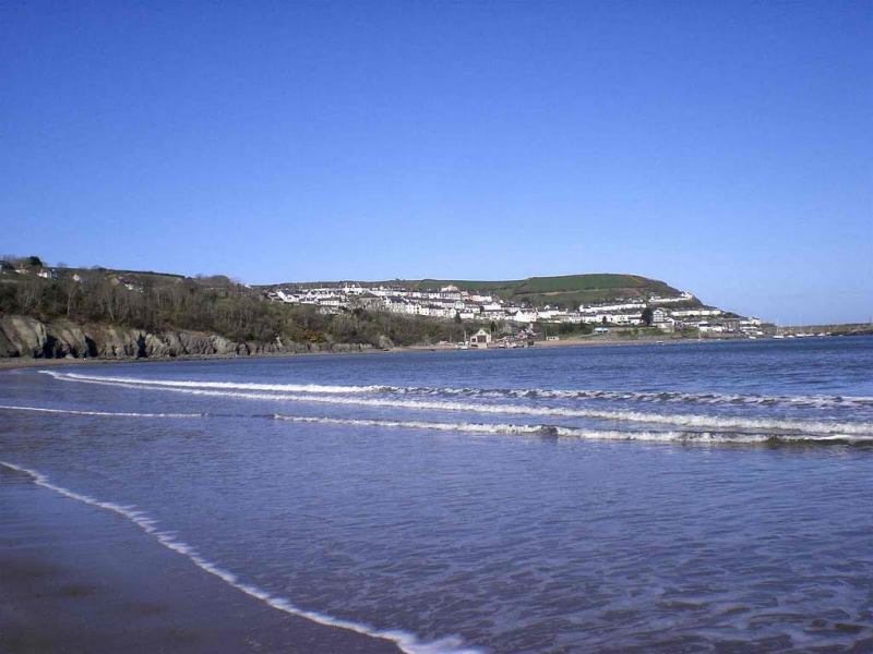
Traeth Gwyn Beach is situated at the eastern end of Newquay's sweeping sandy bay, facing north and located within the waters of Cardigan Bay. The beach is surrounded by steep cliffs, agricultural land, caravan parks, and the village of New Quay, which is less than 1 kilometre away. The coastal waters and coastal belt are designated as the Cardigan Bay Special Area of Conservation and Aberarth Cerreg Wylan Site of Special Scientific Interest, confirming the high conservation status of the area.
New Quay was once an important centre for fishing and ship building. Today, it is a popular holiday resort and one of Wales's top sailing destinations. The village has a rich literary history, with poet Dylan Thomas living there for a time and drawing inspiration from the local community for his works, including "Under Milk Wood".
Traeth Gwyn Beach stretches around New Quay Bay, from the lifeboat station to Llaina Point, offering a wide expanse of sandy beach, especially at low tide. The beach is backed by trees, with a holiday park and caravan park located behind. Visitors can enjoy a range of activities, including swimming, fishing, and walking, with the Ceredigion Coast Path passing close by. The beach is also dog-friendly year-round, making it an ideal destination for pet owners.
Traeth Gwyn Beach is located in New Quay, Ceredigion, Wales, and is easily accessible. The beach offers ample space for beach activities such as sunbathing, picnicking, and playing games, making it more accommodating for families compared to other nearby beaches.
Traeth Gwyn New Quay Beach is adjacent to the Ceredigion Coast Path and the Wales Coast Path.
Sand
| Today |  |
|---|---|
| Chance of rain | 25% |
| Max temperature | 12°C |
| feels like | 10°C |
| Wind 35mph |  |
| Max UV Index |  |
| Tonight |  |
|---|---|
| Chance of rain | 71% |
| Min temperature | 10°C |
| feels like | 8°C |
| Wind 21mph | |
The tide at Traeth Gwyn New Quay Beach is currently falling. Low tide will be at approximately 2:31 PM, and the next high tide will be at approximately 8:01 PM.
Detailed weather and tides »Parking is 5 minutes walk from this beach.
No lifeguard cover at this beach

Good water quality
less than a mile west-northwest as the seagull flies, less than a mile by road.
less than a mile northwest as the seagull flies, less than a mile by road or less than a mile on foot using coastal paths.
less than a mile northwest as the seagull flies, less than a mile by road or less than a mile on foot using coastal paths.
less than a mile east-northeast as the seagull flies, around 2 miles by road or just over a mile on foot using coastal paths.
just over a mile east as the seagull flies, around 2 miles by road or just over a mile on foot using coastal paths.
around 3 miles west-southwest as the seagull flies, around 4 miles by road.
around 3 miles east-northeast as the seagull flies, around 6 miles by road or 4 miles on foot using coastal paths.
around 4 miles east-northeast as the seagull flies, around 7 miles by road or 5 miles on foot using coastal paths.
around 4 miles east-northeast as the seagull flies, around 8 miles by road or 6 miles on foot using coastal paths.
around 5 miles east-northeast as the seagull flies, around 8 miles by road.
around 6 miles east-northeast as the seagull flies, around 9 miles by road.
around 6 miles southwest as the seagull flies, around 13 miles by road or 8 miles on foot using coastal paths.
around 6 miles southwest as the seagull flies, around 13 miles by road or 8 miles on foot using coastal paths.
around 8 miles southwest as the seagull flies, around 13 miles by road or 10 miles on foot using coastal paths.
around 8 miles northeast as the seagull flies, around 12 miles by road.
around 9 miles southwest as the seagull flies, around 15 miles by road or 11 miles on foot using coastal paths.
around 9 miles northeast as the seagull flies, around 12 miles by road.
around 10 miles west-southwest as the seagull flies, around 16 miles by road or 13 miles on foot using coastal paths.
around 10 miles northeast as the seagull flies, around 15 miles by road.
around 13 miles west-southwest as the seagull flies, around 21 miles by road.
Location: Ceinewydd (New Quay)
Location type: Village
OS Grid: SN393595
Coordinates: 52°12'38"N 4°21'10"W
Mapcode: GBR DD.2WFF
What 3 Words: active.mentioned.siesta
Coordinates and location codes are for an approximate mid-point of the beach, and may not reflect the best access point or the most popular part of the beach.
Country: Wales
Local Authority: Ceredigion
Parish: New Quay
Nearest postcode: SA45 9QT
(for sat-nav purposes only, a beach does not have a postal address!)
Important! Beach information is compiled from a variety of different sources and is correct to the best of our knowledge at the time of compilation. However, information may be incorrectly supplied by our sources or go out of date after publication. BritishBeaches.uk makes no warranty as to the accuracy of any information on this page.