Approximate Location Map
Use two fingers to pan or zoom the map
Use two fingers to pan or zoom the map
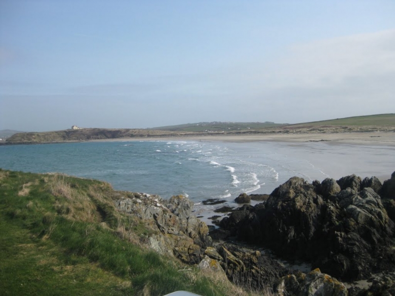
Traeth Tywyn Mawr Beach is a long and sandy beach with sand dunes, stretching half a mile in length. The beach is backed by low dunes and offers a rural feel, with a backdrop of fields and the headland of Trwyn Llwyd to the north.
The beach is suitable for most water sports, including sailing, jet-skiing, kite-surfing, kayaking, and surfing. There are limited facilities at the beach itself, but visitors can find toilets and a shop in nearby Church Bay or Llanfaethlu. However, there are a couple of caravan parks at the southern end of the beach, including Penrhyn and Sandy Beach Leisure Park, which offer amenities such as a well-stocked shop open to non-residents and day visitors.
The beach is close to a village and a campsite, providing accommodation options for visitors. The nearby holiday park overlooking the south corner of the beach makes it a popular family destination.
Traeth Tywyn Mawr Beach is adjacent to the Anglesey Coast Path and the Wales Coast Path.
Sand
| Today |  |
|---|---|
| Chance of rain | 100% |
| Max temperature | 16°C |
| feels like | 17°C |
| Wind 32mph |  |
| Max UV Index |  |
| Tonight | |
|---|---|
| Chance of rain | 100% |
| Min temperature | 12°C |
| feels like | 9°C |
| Wind 36mph |  |
The tide at Traeth Tywyn Mawr Beach is currently falling. Low tide will be at approximately 3:59 PM, and the next high tide will be at approximately 10:10 PM.
Detailed weather and tides » Campsite
There is a car park by the beach.
No lifeguard cover at this beach



Water quality not measured here
around 2 miles north-northeast as the seagull flies, around 6 miles by road or 2 miles on foot using coastal paths.
around 3 miles north-northeast as the seagull flies, around 7 miles by road or 3 miles on foot using coastal paths.
around 3 miles west-southwest as the seagull flies, around 11 miles by road.
around 4 miles south-southwest as the seagull flies, around 8 miles by road.
around 5 miles southwest as the seagull flies, around 12 miles by road.
around 6 miles north-northeast as the seagull flies, around 10 miles by road or 7 miles on foot using coastal paths.
around 6 miles south as the seagull flies, around 10 miles by road.
around 6 miles south as the seagull flies, around 9 miles by road.
around 7 miles northeast as the seagull flies, around 11 miles by road.
around 7 miles south-southeast as the seagull flies, around 15 miles by road.
around 8 miles northeast as the seagull flies, around 12 miles by road or 9 miles on foot using coastal paths.
around 8 miles south-southeast as the seagull flies, around 15 miles by road.
around 9 miles south-southeast as the seagull flies, around 15 miles by road.
around 9 miles south-southeast as the seagull flies, around 15 miles by road.
around 9 miles south-southeast as the seagull flies, around 15 miles by road.
around 10 miles northeast as the seagull flies, around 15 miles by road.
around 12 miles south-southeast as the seagull flies, around 18 miles by road.
around 13 miles east-northeast as the seagull flies, around 18 miles by road.
around 13 miles east as the seagull flies, around 21 miles by road or 17 miles on foot using coastal paths.
around 14 miles east as the seagull flies, around 23 miles by road or 18 miles on foot using coastal paths.
Location: Llanfwrog
Location type: Rural
OS Grid: SH287851
Coordinates: 53°20'6"N 4°34'21"W
Mapcode: GBR HM2W.J59
What 3 Words: roadblock.weeks.pins
Coordinates and location codes are for an approximate mid-point of the beach, and may not reflect the best access point or the most popular part of the beach.
Country: Wales
Local Authority: Isle of Anglesey
Parish: Llanfaethlu
Nearest postcode: LL65 4YH
(for sat-nav purposes only, a beach does not have a postal address!)
Important! Beach information is compiled from a variety of different sources and is correct to the best of our knowledge at the time of compilation. However, information may be incorrectly supplied by our sources or go out of date after publication. BritishBeaches.uk makes no warranty as to the accuracy of any information on this page.