Approximate Location Map
Use two fingers to pan or zoom the map
Use two fingers to pan or zoom the map
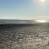
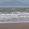
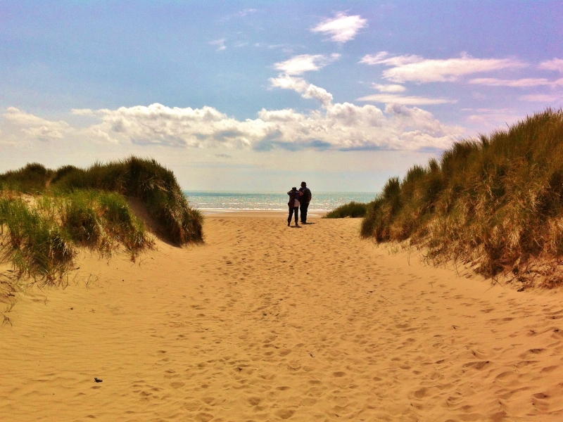
Harlech Beach is a long, sandy beach stretching for 9 kilometres, backed by sand dunes and situated within the Snowdonia National Park. The beach is designated as part of the Lleyn Peninsula and the Sarnau Special Area of Conservation, Morfa Harlech Site of Special Scientific Interest, and a National Nature Reserve.
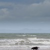
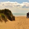
The beach provides a four-mile stretch of pristine golden sand, with stunning views of the Snowdonia mountain range. The area is home to the Morfa Harlech National Nature Reserve, which features Wales's only growing dune system and provides a good example of the effects of longshore drift. To the south of the beach lies Shell Island, a promontory known for its abundance of shells. The beach is also a popular spot for families and dog walkers, although there are restrictions on dog walking at certain times of the year.
During the summer months, leatherback turtles migrate to the waters off Harlech Beach to feed off jellyfish. In 1988, a record-breaking 916kg leatherback was washed up on the beach after becoming tangled in fishing equipment. The clear waters make swimming generally safe, although there is no lifeguard presence and jellyfish can occasionally be found in the area.
The 13th-century Harlech Castle stands on the cliff above the beach, approximately 1000 metres behind the shore. The castle was built as a stronghold by Edward I and played a significant role in The War of the Roses and the English Civil War. It is open to visitors throughout the year. When it was first built, the castle stood immediately next to the sea, but over the centuries, the coastline has shifted significantly. Nearby, the Royal St. David's Golf Club offers stunning sea views and is overlooked by Harlech Castle.
To access the beach, take the Ffordd Glan Mor road from the village of Harlech, past the Min-y-don Holiday Park, and park in the pay-for car park. A 400-metre path leads down to the beach from the car park.
Harlech Beach is adjacent to the Wales Coast Path.
Sand
| Today | |
|---|---|
| Chance of rain | 99% |
| Max temperature | 15°C |
| feels like | 15°C |
| Wind 19mph | |
| Max UV Index |
| Tonight | |
|---|---|
| Chance of rain | 86% |
| Min temperature | 10°C |
| feels like | 10°C |
| Wind 17mph |
The tide at Harlech Beach is currently rising. High tide will be at approximately 11:28 AM, and the next low tide will be at approximately 5:38 PM.
![]() Today's air pollution levels are forecast to be Low
Today's air pollution levels are forecast to be Low
There is a car park bu the beach - a charge applies.
Dog restrictions apply.
No lifeguard cover at this beach
![]()
![]()
Excellent water quality
Coetsiws

From £2385.00 per week at Sykes Holiday Cottages
Tywod a Mor

From £1809.00 per week at Sykes Holiday Cottages
Yr Hen Dy

From £1961.00 per week at Sykes Holiday Cottages
Y Betws

From £2078.00 per week at Sykes Holiday Cottages
40 New Row

From £1777.00 per week at Sykes Holiday Cottages
Harlech Apartments - Bendigeidfran

From £1994.00 per week at Sykes Holiday Cottages
Harlech Leisure (0.6 miles)
Chwarel Hen Llanfair Slate Caverns (0.7 miles)
Harlech Castle (0.8 miles)
Hufenfa'r Castell (0.8 miles)
Children's Farm Park (1.8 miles)
Adrenalin Addicts (1.9 miles)
Snowdonia Adventure Activities (2.4 miles)
Nantcol Waterfalls (3.7 miles)
All distances are approximate
around 2 miles south as the seagull flies, around 3 miles by road.
around 3 miles north-northwest as the seagull flies, around 14 miles by road.
around 4 miles north as the seagull flies, around 11 miles by road.
around 5 miles northwest as the seagull flies, around 14 miles by road.
around 5 miles south as the seagull flies, around 7 miles by road.
around 6 miles northwest as the seagull flies, around 15 miles by road.
around 6 miles northwest as the seagull flies, around 15 miles by road.
around 6 miles south as the seagull flies, around 8 miles by road.
around 9 miles west-northwest as the seagull flies, around 19 miles by road.
around 10 miles south-southeast as the seagull flies, around 11 miles by road.
around 11 miles west-northwest as the seagull flies, around 22 miles by road.
around 12 miles south-southeast as the seagull flies, around 25 miles by road or 17 miles on foot using coastal paths.
around 12 miles west as the seagull flies, around 24 miles by road.
around 13 miles south as the seagull flies, around 27 miles by road or 20 miles on foot using coastal paths.
around 15 miles west as the seagull flies, around 27 miles by road.
around 16 miles northwest as the seagull flies, around 27 miles by road.
around 16 miles northwest as the seagull flies, around 25 miles by road.
around 16 miles west-southwest as the seagull flies, around 31 miles by road.
around 16 miles west as the seagull flies, around 30 miles by road.
around 18 miles west-northwest as the seagull flies, around 30 miles by road.
Location: Lower Harlech,
Location type: Town
OS Grid: SH568314
Coordinates: 52°51'39"N 4°7'37"W
Mapcode: GBR 5P.RZXK
What 3 Words: clincher.apricot.legwork
Coordinates and location codes are for an approximate mid-point of the beach, and may not reflect the best access point or the most popular part of the beach.
Country: Wales
Local Authority: Gwynedd
Parish: Harlech
Nearest postcode: LL46 2UG
(for sat-nav purposes only, a beach does not have a postal address!)
Important! Beach information is compiled from a variety of different sources and is correct to the best of our knowledge at the time of compilation. However, information may be incorrectly supplied by our sources or go out of date after publication. BritishBeaches.uk makes no warranty as to the accuracy of any information on this page.
(Or après-beach. Or pre-beach. Or, just because you might want stuff)
Men's Tops
Weird Fish Fished Branded T-Shirt Black Size S

Only £25.00 from Weird Fish