Approximate Location Map
Use two fingers to pan or zoom the map
Use two fingers to pan or zoom the map
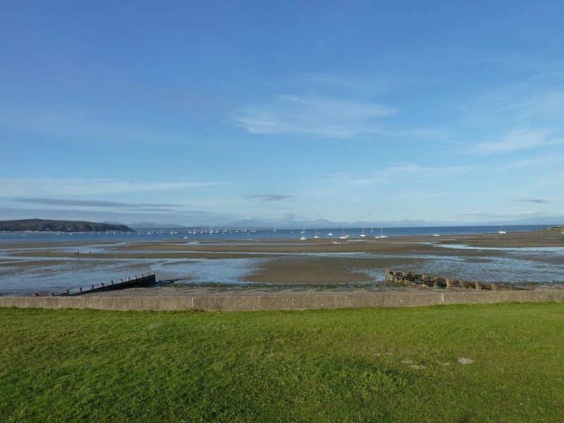
Machroes Beach is a long, sandy beach surrounded by a rugged seascape, making it an ideal spot for a range of water activities. The beach is popular for windsurfing and sailing, and there is a picnic area for those looking to enjoy a meal with a view. Disabled access and facilities are also available, making the beach accessible to everyone.
The beach is located to the south of the town of Abersoch and is backed by the Abersoch Golf Club. Abersoch Beach Cafe is located towards the northern part of the beach, while a small car park, café, picnic area, shop, and public toilets can be found at the southern end. The beach is accessed via a slipway and features a number of wooden groynes to prevent erosion. A fairly large car park is also available on the outskirts of Abersoch, a short walk from the beach.
The area is popular for a range of water sports, including sailing, windsurfing, jet-skiing, and canoeing. The beach merges with Abersoch Beach to the north, where there is a yacht club.
Dogs are banned on the beach from May until September. Further facilities, such as restaurants, pubs, shops, and places to stay, can be found in the former fishing village of Abersoch, which is now a centre for tourism.
Sand
| Today |  |
|---|---|
| Chance of rain | 37% |
| Max temperature | 13°C |
| feels like | 10°C |
| Wind 36mph |  |
| Max UV Index |  |
| Tonight |  |
|---|---|
| Chance of rain | 54% |
| Min temperature | 10°C |
| feels like | 7°C |
| Wind 22mph | |
The tide at Machroes Beach is currently falling. Low tide will be at approximately 3:03 PM, and the next high tide will be at approximately 8:17 PM.
Detailed weather and tides » Campsite
 Food available
 Toilets
 Shops
Shops
 Slipway
There is car parking next to the beach - a charge applies.
Restrictions apply.
No lifeguard cover at this beach


Water quality not measured here
less than a mile north-northwest as the seagull flies, just over a mile by road.
around 2 miles west as the seagull flies, around 3 miles by road.
around 3 miles north-northeast as the seagull flies, around 4 miles by road.
around 6 miles north-northeast as the seagull flies, around 9 miles by road.
around 8 miles northeast as the seagull flies, around 11 miles by road.
around 9 miles northwest as the seagull flies, around 12 miles by road.
around 9 miles north as the seagull flies, around 14 miles by road.
around 9 miles north as the seagull flies, around 14 miles by road.
around 9 miles north-northwest as the seagull flies, around 14 miles by road.
around 9 miles west as the seagull flies, around 13 miles by road.
around 10 miles west as the seagull flies, around 14 miles by road.
around 10 miles northeast as the seagull flies, around 13 miles by road.
around 13 miles north-northeast as the seagull flies, around 17 miles by road.
around 13 miles northeast as the seagull flies, around 17 miles by road.
around 13 miles northeast as the seagull flies, around 17 miles by road.
around 14 miles east-northeast as the seagull flies, around 22 miles by road.
around 15 miles east-northeast as the seagull flies, around 26 miles by road.
around 16 miles east as the seagull flies, around 33 miles by road.
around 16 miles east as the seagull flies, around 37 miles by road.
around 16 miles east-northeast as the seagull flies, around 31 miles by road.
Location: Machroes
Location type: Village
OS Grid: SH318266
Coordinates: 52°48'40"N 4°29'45"W
Mapcode: GBR 57.VSFX
What 3 Words: honeybees.remote.fondest
Coordinates and location codes are for an approximate mid-point of the beach, and may not reflect the best access point or the most popular part of the beach.
Country: Wales
Local Authority: Gwynedd
Parish: Llanengan
Nearest postcode: LL53 7EU
(for sat-nav purposes only, a beach does not have a postal address!)
Important! Beach information is compiled from a variety of different sources and is correct to the best of our knowledge at the time of compilation. However, information may be incorrectly supplied by our sources or go out of date after publication. BritishBeaches.uk makes no warranty as to the accuracy of any information on this page.