Approximate Location Map
Use two fingers to pan or zoom the map
Use two fingers to pan or zoom the map
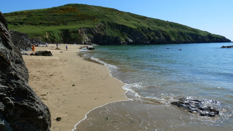
Hemmick Beach is a beautiful and sheltered sandy cove, reached by travelling down a long, narrow road from Boswinger, west of Gorran Haven. The beach is perfect for building sandcastles, and at low tide, numerous rock pools emerge, offering endless exploration opportunities for curious kids and adults.
There are no facilities or toilets at Hemmick Beach, but visitors can access a National Trust car park, located about a 10-15 minute walk away in the old farming hamlet of Penare. The car park has limited spaces (about 20), so it's recommended to arrive early during peak times. Alternatively, visitors can park near the beach, but be aware that the road is extremely narrow and steep, suitable only for small cars, and there's very limited parking available (space for only about 3 cars).
The beach is safe for swimming, and the waters are inviting, especially during the summer months. Beyond the beach itself, Hemmick serves as a great starting point for coastal walks, with stunning paths leading in both directions, offering breathtaking views of Cornwall's dramatic coastline. Visitors can take the South West Coast Path down to Dodmans Point and enjoy the natural beauty and scenic surroundings.
It's essential to note that access to Hemmick Beach can sometimes require some planning. The recommended approach is to park at the National Trust car park at Penare and enjoy a lovely walk down to the beach. However, the walk from the car park and the beach access might be challenging for those with mobility issues or carrying lots of beach gear.
Hemmick Beach is on The Roseland Heritage Coast, and adjacent to the South West Coast Path.
Cove Sand
| Today |  |
|---|---|
| Chance of rain | 100% |
| Max temperature | 16°C |
| feels like | 17°C |
| Wind 24mph |  |
| Max UV Index |  |
| Tonight | |
|---|---|
| Chance of rain | 100% |
| Min temperature | 13°C |
| feels like | 13°C |
| Wind 30mph | |
The tide at Hemmick Beach is currently rising. High tide will be at approximately 6:07 AM, and the next low tide will be at approximately 12:30 PM.
Detailed weather and tides »National Trust car park just up the lane with safe footpath connecting to the beach. No parking at the beach.
Dogs are allowed. Please clear up and take all litter home.
Monthly beach cleans, first Saturday of the month.
No lifeguard cover at this beach

Water quality not measured here
just over a mile east-northeast as the seagull flies, around 3 miles by road or just over a mile on foot using coastal paths.
just over a mile west-northwest as the seagull flies, around 2 miles by road.
just over a mile northeast as the seagull flies, around 3 miles by road or 2 miles on foot using coastal paths.
just over a mile northeast as the seagull flies, around 3 miles by road or 2 miles on foot using coastal paths.
around 2 miles west as the seagull flies, around 5 miles by road or 3 miles on foot using coastal paths.
around 3 miles north-northeast as the seagull flies, around 3 miles by road.
around 3 miles north-northeast as the seagull flies, around 5 miles by road.
around 3 miles north-northeast as the seagull flies, around 5 miles by road.
around 4 miles west-southwest as the seagull flies, around 9 miles by road or 5 miles on foot using coastal paths.
around 4 miles north-northeast as the seagull flies, around 6 miles by road.
around 6 miles west-southwest as the seagull flies, around 10 miles by road or 7 miles on foot using coastal paths.
around 6 miles west-southwest as the seagull flies, around 10 miles by road or 8 miles on foot using coastal paths.
around 7 miles north-northeast as the seagull flies, around 9 miles by road.
around 7 miles north-northeast as the seagull flies, around 10 miles by road.
around 7 miles west-southwest as the seagull flies, around 12 miles by road or 9 miles on foot using coastal paths.
around 7 miles north-northeast as the seagull flies, around 10 miles by road.
around 7 miles north-northeast as the seagull flies, around 10 miles by road.
around 8 miles west-southwest as the seagull flies, around 12 miles by road or 10 miles on foot using coastal paths.
around 8 miles west-southwest as the seagull flies, around 13 miles by road or 10 miles on foot using coastal paths.
around 8 miles north-northeast as the seagull flies, around 11 miles by road.
Location: Penare
Location type: Rural
Nearest village: Gorran Churchtown
OS Grid: SW994404
Coordinates: 50°13'47"N 4°48'48"W
Mapcode: GBR ZW.6QXT
What 3 Words: renders.converter.tulip
Coordinates and location codes are for an approximate mid-point of the beach, and may not reflect the best access point or the most popular part of the beach.
Country: England
Local Authority: Cornwall
Parish: St. Goran
Nearest postcode: PL26 6LL
(for sat-nav purposes only, a beach does not have a postal address!)
Important! Beach information is compiled from a variety of different sources and is correct to the best of our knowledge at the time of compilation. However, information may be incorrectly supplied by our sources or go out of date after publication. BritishBeaches.uk makes no warranty as to the accuracy of any information on this page.