Approximate Location Map
Use two fingers to pan or zoom the map
Use two fingers to pan or zoom the map
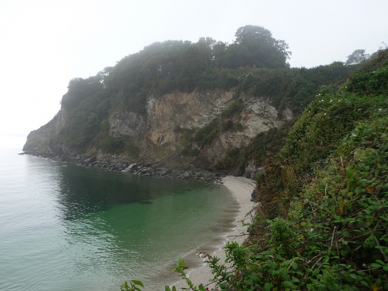
Duporth Beach is a sandy beach, approximately 450 metres wide, situated between Charlestown and Porthpean. The beach is backed by cliffs and can be accessed by foot only, either from the coast path or via parking at Porthpean.
The beach is a quiet sand and shingle beach with rock pools exposed at low tide. Above the cliffs that back the beach, there are private houses and new developments. The name 'Duporth' means 'Two Coves' in Cornish. Along the northeastern end of the beach, visitors can find the WW2 Crinnis Cliff Gun Battery, which is located along the South West Coast Path. There are no facilities or parking directly at the beach, with the nearest being at Porthpean and Charlestown.
Duporth Beach is adjacent to the South West Coast Path.
Sand
| Today |  |
|---|---|
| Chance of rain | 15% |
| Max temperature | 14°C |
| feels like | 13°C |
| Wind 12mph |  |
| Max UV Index |  |
| Tonight |  |
|---|---|
| Chance of rain | 98% |
| Min temperature | 10°C |
| feels like | 9°C |
| Wind 26mph |  |
The tide at Duporth Beach is currently falling. Low tide will be at approximately 7:45 PM, and the next high tide will be at approximately 2:05 AM tomorrow.
 Today's air pollution levels are forecast to be Low
Parking available at Charlestown.
Dogs not allowed.
No lifeguard cover at this beach


Water quality not measured here
less than a mile northeast as the seagull flies, less than a mile by road or less than a mile on foot using coastal paths.
less than a mile southwest as the seagull flies, just over a mile by road or less than a mile on foot using coastal paths.
less than a mile northeast as the seagull flies, less than a mile by road or less than a mile on foot using coastal paths.
just over a mile east-northeast as the seagull flies, around 2 miles by road.
around 2 miles east-northeast as the seagull flies, around 3 miles by road.
around 3 miles south-southwest as the seagull flies, around 4 miles by road.
around 3 miles east-northeast as the seagull flies, around 5 miles by road.
around 4 miles east-northeast as the seagull flies, around 6 miles by road.
around 4 miles south-southwest as the seagull flies, around 5 miles by road.
around 4 miles south-southwest as the seagull flies, around 5 miles by road.
around 4 miles east as the seagull flies, around 7 miles by road.
around 5 miles south-southwest as the seagull flies, around 6 miles by road.
around 5 miles east as the seagull flies, around 8 miles by road.
around 6 miles south as the seagull flies, around 9 miles by road.
around 6 miles south as the seagull flies, around 9 miles by road.
around 7 miles south as the seagull flies, around 9 miles by road.
around 7 miles south-southwest as the seagull flies, around 10 miles by road.
around 7 miles south-southwest as the seagull flies, around 11 miles by road.
around 8 miles southwest as the seagull flies, around 13 miles by road.
around 9 miles southwest as the seagull flies, around 14 miles by road.
Location: Duporth
Location type: Urban
OS Grid: SX035511
Coordinates: 50°19'39"N 4°45'40"W
Mapcode: GBR N1.XLV4
What 3 Words: dazzling.boots.enthused
Coordinates and location codes are for an approximate mid-point of the beach, and may not reflect the best access point or the most popular part of the beach.
Country: England
Local Authority: Cornwall
Parish: St Austell Bay
Nearest postcode: PL26 6AQ
(for sat-nav purposes only, a beach does not have a postal address!)
Important! Beach information is compiled from a variety of different sources and is correct to the best of our knowledge at the time of compilation. However, information may be incorrectly supplied by our sources or go out of date after publication. BritishBeaches.uk makes no warranty as to the accuracy of any information on this page.