Approximate Location Map
Use two fingers to pan or zoom the map
Use two fingers to pan or zoom the map
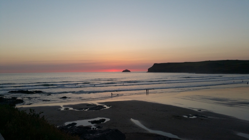
Polzeath Beach is a sand and shingle beach with some rocks, situated at the mouth of a river and backed by interesting cliffs. The beach features rock pools and includes a voluntary marine nature reserve. It is approximately 640 metres wide and has a stream flowing across it.
Polzeath Beach is located just north of the Camel Estuary on the north coast of Cornwall. The beach is backed by cliffs and offers stunning views of the surrounding landscape.
The beach has a sandchair hire scheme, making it accessible to visitors with mobility issues. There are plenty of pubs, shops, cafes, and restaurants in the village, as well as surf schools and clubs catering to beginners and experienced surfers alike. Polzeath Beach is a popular spot for both surfers and holidaymakers, and can get crowded during the summer months.
The beach is dog friendly during the winter months, but there are restrictions in place during the summer season.
The beach is an old favourite with families and has been a popular destination for holidaymakers for many years. Sir John Betjeman, a famous British poet and writer, is buried in the nearby Church of St Enodoc.
Polzeath Beach is adjacent to the South West Coast Path.
Sand Shingle
| Today |  |
|---|---|
| Chance of rain | 10% |
| Max temperature | 14°C |
| feels like | 14°C |
| Wind 14mph |  |
| Max UV Index |  |
| Tonight |  |
|---|---|
| Chance of rain | 93% |
| Min temperature | 12°C |
| feels like | 9°C |
| Wind 34mph |  |
The tide at Polzeath Beach is currently falling. Low tide will be at approximately 8:09 PM, and the next high tide will be at approximately 2:15 AM tomorrow.
 Today's air pollution levels are forecast to be Low
 Campsite
 Food available
 Toilets
 Shops
Shops
 Litter bins
There is pay parking available at the beach for 150 cars, including disabled spaces.
Seasonal ban in place between Easter Sunday and 30 September.
Beach cleaned daily during the summer.

Daily - 30th April - 25th September
Weekends - 16th -24th April; 1st - 16th October
Easter - 25th March - 10th April
Oct half term - 22nd - 30th October



Water quality not measured here
less than a mile southwest as the seagull flies, just over a mile by road or less than a mile on foot using coastal paths.
just over a mile south-southwest as the seagull flies, just over a mile by road.
around 2 miles south as the seagull flies, around 3 miles by road or 3 miles on foot using coastal paths.
around 4 miles east-northeast as the seagull flies, around 7 miles by road or 5 miles on foot using coastal paths.
around 7 miles east-northeast as the seagull flies, around 10 miles by road.
around 8 miles northeast as the seagull flies, around 12 miles by road.
around 9 miles northeast as the seagull flies, around 14 miles by road.
around 10 miles northeast as the seagull flies, around 14 miles by road.
around 13 miles northeast as the seagull flies, around 17 miles by road.
around 17 miles northeast as the seagull flies, around 24 miles by road.
around 18 miles south-southeast as the seagull flies, around 26 miles by road.
around 18 miles south-southeast as the seagull flies, around 26 miles by road.
around 18 miles south-southeast as the seagull flies, around 26 miles by road.
around 18 miles south-southeast as the seagull flies, around 26 miles by road.
around 19 miles south-southeast as the seagull flies, around 24 miles by road.
around 19 miles south-southeast as the seagull flies, around 26 miles by road.
around 19 miles south-southeast as the seagull flies, around 26 miles by road.
around 19 miles south-southeast as the seagull flies, around 26 miles by road.
around 21 miles south-southeast as the seagull flies, around 27 miles by road.
around 21 miles southeast as the seagull flies, around 26 miles by road.
Location: Polzeath
Location type: Village
OS Grid: SW934791
Coordinates: 50°34'30"N 4°55'8"W
Mapcode: GBR ZP.6TBN
What 3 Words: mocked.dries.alarm
Coordinates and location codes are for an approximate mid-point of the beach, and may not reflect the best access point or the most popular part of the beach.
Country: England
Local Authority: Cornwall
Parish: St. Minver Highlands
Nearest postcode: PL27 6TB
(for sat-nav purposes only, a beach does not have a postal address!)
Important! Beach information is compiled from a variety of different sources and is correct to the best of our knowledge at the time of compilation. However, information may be incorrectly supplied by our sources or go out of date after publication. BritishBeaches.uk makes no warranty as to the accuracy of any information on this page.