Approximate Location Map
Use two fingers to pan or zoom the map
Use two fingers to pan or zoom the map
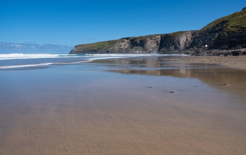
Trebarwith Strand Beach is situated approximately a mile and a half south of Tintagel, a historic castle and village. The beach is a large, sandy bay, approximately 800 metres wide, sheltered by high rocky cliffs with many caves and rock pools. A stream flows across the beach into the sea, adding to the natural beauty of the area.
The beach is backed by cliffs and caves, making it a popular spot for exploration and rock pooling. At high tide, the beach is completely covered, revealing the rocky shoreline. A cafe opens during the holiday season, providing refreshments for visitors. Tintagel Castle, a famous historic site, lies just under two miles away.
Trebarwith Strand Beach is popular with surfers, who come to take advantage of the beach's consistent waves. Access to the beach involves a scramble over rocks, which can be challenging for some visitors. The beach's unique landscape and natural beauty have made it a popular location for film crews, with movies such as 'Saving Grace' and 'Twelfth Night' having been filmed here.
Trebarwith Strand Beach is on the Pentire Point - Widemouth Heritage Coast, and adjacent to the South West Coast Path.
Sand
| Today |  |
|---|---|
| Chance of rain | 100% |
| Max temperature | 16°C |
| feels like | 17°C |
| Wind 24mph |  |
| Max UV Index |  |
| Tonight | |
|---|---|
| Chance of rain | 100% |
| Min temperature | 12°C |
| feels like | 10°C |
| Wind 30mph |  |
The tide at Trebarwith Strand Beach is currently falling. Low tide will be at approximately 10:57 AM, and the next high tide will be at approximately 5:51 PM.
Detailed weather and tides » Food available
 Toilets
 Shops
Shops
There is a council run car park a five minute walk from the beach.

Daily - 21st May - 25th September


Water quality not measured here
around 2 miles south-southwest as the seagull flies, around 4 miles by road or 3 miles on foot using coastal paths.
around 2 miles north as the seagull flies, around 3 miles by road or 2 miles on foot using coastal paths.
around 2 miles north-northeast as the seagull flies, around 3 miles by road.
around 4 miles northeast as the seagull flies, around 8 miles by road or 5 miles on foot using coastal paths.
around 5 miles southwest as the seagull flies, around 9 miles by road.
around 8 miles southwest as the seagull flies, around 12 miles by road.
around 9 miles northeast as the seagull flies, around 16 miles by road or 10 miles on foot using coastal paths.
around 9 miles southwest as the seagull flies, around 13 miles by road.
around 9 miles southwest as the seagull flies, around 13 miles by road.
around 10 miles southwest as the seagull flies, around 14 miles by road.
around 13 miles northeast as the seagull flies, around 18 miles by road.
around 14 miles northeast as the seagull flies, around 18 miles by road.
around 16 miles northeast as the seagull flies, around 21 miles by road.
around 16 miles northeast as the seagull flies, around 21 miles by road.
around 17 miles north-northeast as the seagull flies, around 23 miles by road.
around 17 miles north-northeast as the seagull flies, around 25 miles by road.
around 21 miles south as the seagull flies, around 29 miles by road.
around 21 miles south as the seagull flies, around 31 miles by road.
around 21 miles south as the seagull flies, around 31 miles by road.
around 21 miles south as the seagull flies, around 31 miles by road.
Location: Trebarwith Strand
Location type: Rural
OS Grid: SX048864
Coordinates: 50°38'40"N 4°45'43"W
Mapcode: GBR N1.8LLD
What 3 Words: tributes.starters.slopes
Coordinates and location codes are for an approximate mid-point of the beach, and may not reflect the best access point or the most popular part of the beach.
Country: England
Local Authority: Cornwall
Parish: Tintagel
Nearest postcode: PL34 0HA
(for sat-nav purposes only, a beach does not have a postal address!)
Important! Beach information is compiled from a variety of different sources and is correct to the best of our knowledge at the time of compilation. However, information may be incorrectly supplied by our sources or go out of date after publication. BritishBeaches.uk makes no warranty as to the accuracy of any information on this page.


