Approximate Location Map
Use two fingers to pan or zoom the map
Use two fingers to pan or zoom the map
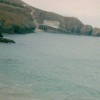
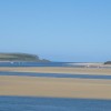
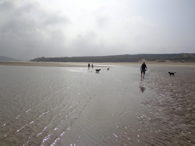
Rock Beach is situated on the north coast of Cornwall, on the eastern side of the Camel Estuary, which is an Area of Outstanding Natural Beauty (AONB). The beach stretches out in front of the village of Rock and is approximately 800 metres wide. It is an intertidal beach, backed by sand dunes that extend for three kilometres past Brea Hill to Daymer Bay at low water.
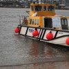
The beach is a long, sandy stretch that, at low tide, connects Porthilly Cove to Daymer Bay. A passenger ferry operates between Rock and the town of Padstow, providing a convenient link between the two. The beach offers a range of activities, including sailing, waterskiing, and sunbathing. During the summer months, the beach can get extremely busy, while in the off-season, visitors can enjoy the charm of the seaside town at a more leisurely pace.
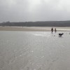
Rock Beach is often referred to as ‘Chelsea on Sea’ due to the presence of many exclusive homes and villas. The beach is dog-friendly during the winter months, but there are restrictions in place during the summer season. Visitors can also take a regular ferry across the river to Padstow Harbour for afternoon trips.
Rock Beach is adjacent to the South West Coast Path.
Sand
| Today | |
|---|---|
| Chance of rain | 100% |
| Max temperature | 15°C |
| feels like | 14°C |
| Wind 28mph | |
| Max UV Index |
| Tonight | |
|---|---|
| Chance of rain | 64% |
| Min temperature | 12°C |
| feels like | 12°C |
| Wind 27mph |
The tide at Rock Beach is currently low. High tide will be at approximately 8:25 AM, and the next low tide will be at approximately 2:44 PM.
![]() Today's air pollution levels are forecast to be Low
Today's air pollution levels are forecast to be Low
Parking is available.
Dogs are welcome here.
No lifeguard cover at this beach
Excellent water quality
Lowenna Manor 10

From £3640.00 per week at Sykes Holiday Cottages
5 Bodmin Hill

From £2302.00 per week at Sykes Holiday Cottages
Brook Cottage (Cornwall)

From £486.00 per week at Rural Retreats
Romantic Cornwall Cottage

From £357.00 per week at Holidaycottages.co.uk
Cornwall Farmhouse
From £611.00 per week at Holidaycottages.co.uk
Luxury Romantic Cornwall Cottage
From £1969.00 per week at Holidaycottages.co.uk
Padstow Sealife Safaris (0.5 miles)
Padstow Brewing Company (0.7 miles)
Padstow and Stepper Point Walk (0.8 miles)
St. Enodoc Church (1 miles)
The Camel Trail (1 miles)
The Camel Trail (1.7 miles)
All distances are approximate
just over a mile north-northwest as the seagull flies, around 3 miles by road or just over a mile on foot using coastal paths.
around 2 miles north as the seagull flies, around 3 miles by road or 2 miles on foot using coastal paths.
around 2 miles north as the seagull flies, around 3 miles by road.
around 5 miles northeast as the seagull flies, around 9 miles by road or 6 miles on foot using coastal paths.
around 9 miles northeast as the seagull flies, around 12 miles by road.
around 10 miles northeast as the seagull flies, around 14 miles by road.
around 11 miles northeast as the seagull flies, around 15 miles by road.
around 12 miles northeast as the seagull flies, around 16 miles by road.
around 14 miles northeast as the seagull flies, around 19 miles by road.
around 19 miles northeast as the seagull flies, around 26 miles by road.
around 23 miles southeast as the seagull flies, around 33 miles by road.
around 23 miles northeast as the seagull flies, around 29 miles by road.
around 24 miles northeast as the seagull flies, around 29 miles by road.
around 24 miles southeast as the seagull flies, around 32 miles by road.
around 25 miles east-southeast as the seagull flies, around 35 miles by road.
around 25 miles east-southeast as the seagull flies, around 35 miles by road.
around 25 miles east-southeast as the seagull flies, around 36 miles by road.
around 25 miles east-southeast as the seagull flies, around 34 miles by road.
around 26 miles northeast as the seagull flies, around 32 miles by road.
around 26 miles northeast as the seagull flies, around 32 miles by road.
Location: Porthilly,
Location type: Village
OS Grid: SW928756
Coordinates: 50°32'38"N 4°55'28"W
Mapcode: GBR ZM.YZL6
What 3 Words: cosmic.merchant.fattest
Coordinates and location codes are for an approximate mid-point of the beach, and may not reflect the best access point or the most popular part of the beach.
Country: England
Local Authority: Cornwall
Parish: St. Minver Lowlands
Nearest postcode: PL27 6FD
(for sat-nav purposes only, a beach does not have a postal address!)
Important! Beach information is compiled from a variety of different sources and is correct to the best of our knowledge at the time of compilation. However, information may be incorrectly supplied by our sources or go out of date after publication. BritishBeaches.uk makes no warranty as to the accuracy of any information on this page.
(Or après-beach. Or pre-beach. Or, just because you might want stuff)
Men's Tops
Weird Fish Pinto Printed Jersey T-Shirt Plum Size 12

Only £17.50 from Weird Fish