Approximate Location Map
Use two fingers to pan or zoom the map
Use two fingers to pan or zoom the map
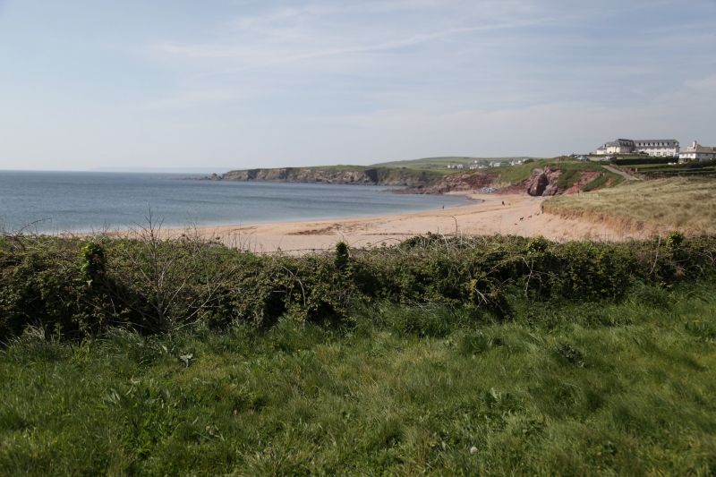
Thurlestone South Beach is located towards South Milton and features coarse sand with rocky outcrops and numerous rock pools to explore at low tide. The beach is approximately 250 metres wide and is backed by sand dunes. A stream flows across the beach to the sea. The most prominent feature of the beach is the famous Thurlstone Rock, best seen at high tide.
The beaches at Thurlestone offer a range of activities, including swimming, watersports, and exploring the rocky outcrops and rock pools. Thurlestone Sands, the larger of the two beaches, is a popular location for a variety of watersports. However, visitors are advised to exercise caution due to the presence of dangerous rip-tides, currents, and sudden shelving. The beach is relatively remote, accessed via a single-track road, which helps to maintain its rural feel.
The beaches are dog-friendly all year round, although there are strongly enforced dog-fouling laws in place to keep the golden sand clean. South Milton Sands, one of the beaches, has a cafe on the beachfront and offers kayak rental. Lifeguards are on duty during the holidays, and the water is clear and suitable for swimming.
Thurlestone South Beach is situated on the south coast of Devon, near South Milton. The beach is relatively remote, which helps to maintain its natural beauty and rural feel.
Thurlestone South Beach is on the South Devon Heritage Coast, and adjacent to the South West Coast Path.
Sand
| Today |  |
|---|---|
| Chance of rain | 81% |
| Max temperature | 14°C |
| feels like | 13°C |
| Wind 18mph |  |
| Max UV Index |  |
| Tonight |  |
|---|---|
| Chance of rain | 25% |
| Min temperature | 9°C |
| feels like | 7°C |
| Wind 12mph | |
The tide at Thurlestone South Beach is currently falling. Low tide will be at approximately 6:01 PM, and the next high tide will be at approximately 12:35 AM tomorrow.
 Today's air pollution levels are forecast to be Low
 Food available
 Toilets
 Shops
Shops
 Litter bins
There is a National Trust Car park by the beach - a charge applies.
Dogs are allowed.
Beach cleaned manually and daily during the summer by the council.

Daily - 9th July - 4th September


Water quality not measured here
less than a mile north-northwest as the seagull flies, around 3 miles by road or less than a mile on foot using coastal paths.
less than a mile northwest as the seagull flies, around 3 miles by road or less than a mile on foot using coastal paths.
less than a mile south as the seagull flies, around 3 miles by road or just over a mile on foot using coastal paths.
just over a mile south as the seagull flies, around 3 miles by road or just over a mile on foot using coastal paths.
around 2 miles northwest as the seagull flies, around 5 miles by road or 2 miles on foot using coastal paths.
around 3 miles south-southeast as the seagull flies, around 4 miles by road.
around 4 miles east-southeast as the seagull flies, around 7 miles by road or 5 miles on foot using coastal paths.
around 4 miles southeast as the seagull flies, around 6 miles by road or 5 miles on foot using coastal paths.
around 9 miles east as the seagull flies, around 12 miles by road.
around 9 miles east as the seagull flies, around 11 miles by road.
around 10 miles east-northeast as the seagull flies, around 13 miles by road.
around 10 miles east-northeast as the seagull flies, around 13 miles by road.
around 12 miles east-northeast as the seagull flies, around 19 miles by road or 14 miles on foot using coastal paths.
around 12 miles east-northeast as the seagull flies, around 18 miles by road or 15 miles on foot using coastal paths.
around 14 miles east-northeast as the seagull flies, around 20 miles by road.
around 2 miles northwest as the seagull flies, around 10 miles by road or 3 miles on foot using coastal paths.
around 2 miles northwest as the seagull flies, around 10 miles by road or 3 miles on foot using coastal paths.
around 2 miles northwest as the seagull flies, around 10 miles by road or 3 miles on foot using coastal paths.
around 2 miles northwest as the seagull flies, around 10 miles by road or 4 miles on foot using coastal paths.
around 3 miles northwest as the seagull flies, around 10 miles by road or 4 miles on foot using coastal paths.
Location: Thurlestone
Location type: Village
OS Grid: SX676416
Coordinates: 50°15'36"N 3°51'28"W
Mapcode: GBR QB.M4PK
What 3 Words: mount.sprouts.wager
Coordinates and location codes are for an approximate mid-point of the beach, and may not reflect the best access point or the most popular part of the beach.
County: Devon
Country: England
Local Authority: South Hams
Parish: South Milton
Nearest postcode: TQ7 3JS
(for sat-nav purposes only, a beach does not have a postal address!)
Important! Beach information is compiled from a variety of different sources and is correct to the best of our knowledge at the time of compilation. However, information may be incorrectly supplied by our sources or go out of date after publication. BritishBeaches.uk makes no warranty as to the accuracy of any information on this page.